

-
AboutMount Heng, an outstanding representative of the splendid mountains and rivers of China, a symbol of national prosperity, a totem of national spirit, an important geographical indication of the country, and holds the status of a national mountain.More
-
CultureHengshan has been a famous scenic spot and important birthplace of Taoism in northern China since ancient times. Carrying the symbols of Chinese civilization, it has nurtured profound regional culture and folk customs.More
-
-
Tourist GuideUnderstand relevant information about the scenic area and enjoy a better travel experience.More
-
Surrounding activitiesThe ancient city of Hunyuan at the foot of Mount Heng in Beiyue has a long history, rich cultural heritage, beautiful scenery, and a convergence of agriculture, commerce, and animal husbandry. It has nurtured a unique regional culture and is renowned for its fine wine and delicious food.More


Why is the ancient city of Hunyuan laid out in a "tortoise city, snake street" pattern?
Publish Time:
2025-03-14 16:24
Source:
Hunyuan Ancient City was built in the Later Tang Dynasty and has been rebuilt by successive dynasties. Because the city walls are octagonal and the streets are winding and tortuous, it is known as "Turtle City Snake Street".
Hunyuan Ancient City was built during the Later Tang dynasty and has been repaired and expanded throughout the dynasties. Because the city walls are octagonal, and the streets are winding and tortuous, it is known as the "Tortoise City and Snake Street". Regarding the origin of Hunyuan Ancient City, the Qianlong edition of "Hunyuan Prefecture Records, Volume 2, Historical Changes" states: "The old city was located to the west of the state, to the left of Hengshan Mountain, with the Xia River flowing around it. During rainy seasons, the river would flood, causing frequent water disasters in the city. During the Later Tang dynasty, the city was relocated to its current location. The earth's veins come from the southeast, converging to form a shape like a tortoise, and the city resembles its form, with the battlements winding like a turtle carrying a scroll."
This passage from the "Hunyuan Prefecture Records" is of vital importance, and the important information it reveals is analyzed below.
I. According to the "Book of Han, Geography", Hunyuan already had a county seat during the Western Han Dynasty, then known as Aolai County. The old city of Aolai County is the same as the old city mentioned in the prefecture records, located to the west of Hengshan Mountain. Through repeated on-site surveys and written research, the old city of Aolai County is located north of present-day Mazhuang Village. The famous scholar, Mr. Yao Dianzhong, also investigated the old city of Aolai County and wrote the plaque "Aolai County's Old Home" for Mazhuang Village.
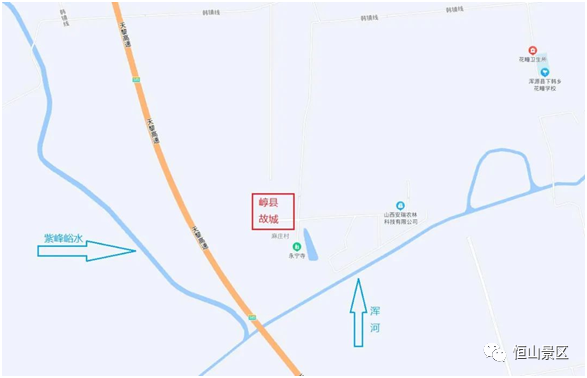
Figure 1: Location diagram of the old city of Aolai County
II. The Xia River mentioned in the prefecture records refers to both the Zipengyu River and the Hun River. The old city of Aolai County is situated between the two rivers, with flat terrain conducive to city planning. However, during heavy rains, the rivers would flood, making the area susceptible to water disasters. Therefore, during the Later Tang dynasty, the city was moved to its present location.
The Zipengyu River is now dry, and the Hun River is also reduced to a trickle. However, historical research cannot rely entirely on present conditions. Hunyuan County is located at the southeastern edge of Datong Basin. The Hun River, which originates within the county, is a tributary of the Sanggan River. According to historical records, the Hun River frequently flooded. For example, the "Yuan Dynasty History, Volume 29, Taiding Emperor I" states: "In May of the first year of Taiding, the Hun River in Datong, the Hutuo River in Zhenzhou, the Wei and Hei Rivers in Shaanxi, and the Jiang River in Quzhou all overflowed, washing away houses and homes." "Volume 30, Taiding Emperor II": "In autumn and July of the third year of Taiding, the Hun River in Datong overflowed." "Volume 50, Five Elements I": "In December of the sixth year of Zhiyuan, Hunyuan County experienced a great flood." The record of the Hun River "washing away houses and homes" shows the ferocity of the floods. In addition, in July 1939, a major flood occurred in Hunyuan Nanyu, causing thousands of people in Hunyuan city to lose their homes and possessions, with some families even completely wiped out, leaving no trace.
I speculate that the annual rainfall in ancient Hunyuan should be between 450 and 550 mm, situated in the transition zone between forest and grassland, suitable for the survival of tigers and leopards. The "Book of Wei" records that the Northern Wei royal family often hunted in Hunyuan and captured tigers and other large felines [1]. Tigers are typical mountain forest-dwelling animals, indicating that the ecological environment of ancient Hunyuan was much better than it is now. When heavy rains caused flooding, the low-lying old city would indeed be easily submerged.
III. How did the ancients plan cities? The "Record of the Craftsmen" in the "Zhou Rituals" provides a standard model: "Craftsmen build a state nine li square, with three gates on each side. The city is divided by nine longitudinal and nine transverse streets, each nine tracks wide. Ancestral temples are on the left and community shrines are on the right, with the court in front and the market in the back." A square grid-like city plan is undoubtedly the ideal urban layout. However, in practice, adjustments are made based on the terrain. For example, Jiankang, the capital city of the Six Dynasties (present-day Nanjing), is bordered by the Yangtze River to the west, the Hou Lake ( Xuanwu Lake) to the north, and Zhongshan Mountain to the east. Buildings could only follow the mountain and water features, resulting in an irregular layout. The "New Anecdotes of the World" states that Prime Minister Wang Dao planned the city of Jiankang because "the land to the east of the river is limited, unlike in central China. If the streets and lanes are straight and spacious, it would be readily visible from end to end, so the plan was made winding and tortuous, appearing immeasurable.". In fact, there was no way to make the urban planning into a neat grid. Hunyuan Ancient City is located at the northern foot of Hengshan Mountain, backed by Hengshan Mountain to the south, and adjacent to the Hun River to the north. The state records state, "The earth's veins come from the southeast, converging to form a shape like a tortoise, and the city resembles its form, with the battlements winding like a turtle carrying a scroll." The ancient writings are obscure and difficult for ordinary readers to understand. In fact, the construction of Hunyuan Ancient City was adapted to the mountain. In order to avoid water disasters, the ancient people chose to build the city on higher ground. Some undulations are needed to transition to the plains. Hunyuan Ancient City is higher in the southeast and lower in the northwest, which made it impossible to build straight streets. Thus, the city walls could only be "winding and tortuous like a turtle carrying a scroll.". Compared to Nanjing City, Hunyuan Ancient City, though also a geomantically auspicious place, is smaller in scale. Nanjing City is called "a dragon crouching and a tiger coiled", while Hunyuan Ancient City is "Tortoise City and Snake Street."
The three elements of architecture are practicality, solidity, and aesthetics. The choice of location for Hunyuan Ancient City was primarily to avoid water disasters. Due to topographic constraints, it adopted the layout of "Tortoise City and Snake Street". Of course, some scholars believe that the planning of Hunyuan Ancient City corresponds to the image of the Xuanwu (black tortoise) in the north. But these are digressions.
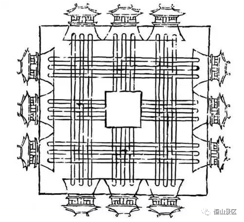
Figure 2: City planning diagram from "Record of the Craftsmen"
Note: [1] "Book of Wei, Volume 27, Biography of Mu Yi":
(Mu) Han's younger brother Yi, was loyal, prudent, and talented. He followed (Emperor Shizu) in the conquest of Helong, his achievements surpassing other generals, and was appointed as the commander of the imperial guards, and given the title of Longxiang General, and promoted to the title of Chang Le Hou. He once followed Emperor Shizu in hunting on Aolai Mountain and encountered a tiger that suddenly appeared. Yi wrestled with it and captured it.
Keywords:
Hengshan
Related News
Contact Us
Beiyue Hengshan Scenic Area:
Travel Inquiry:+86-352-8333077
Ticket Inquiry:+86-352-8333031
Travel Complaints:+86-352-8333081
Emergency Rescue:+86-352-8333037
Mount Hengshan Scenic Area Administration Center (Official)
+86-352-8322142
Hanging Temple
+86-352-8327795
Yuemenwan (Hengshan Mountain Gate)
+86-352-8480060 +86-352-8328318 +86-352-8328530
Hengzong
+86-352-8480115
Tianfeng Ridge
+86-352-8480114
Yong'an Temple
+86-352-8322390
Li's Family Cemetery
+86-352-8322381
Hengshan Cableway
+86-352-8322255
Official Media

Tiktok