

-
AboutMount Heng, an outstanding representative of the splendid mountains and rivers of China, a symbol of national prosperity, a totem of national spirit, an important geographical indication of the country, and holds the status of a national mountain.More
-
CultureHengshan has been a famous scenic spot and important birthplace of Taoism in northern China since ancient times. Carrying the symbols of Chinese civilization, it has nurtured profound regional culture and folk customs.More
-
-
Tourist GuideUnderstand relevant information about the scenic area and enjoy a better travel experience.More
-
Surrounding activitiesThe ancient city of Hunyuan at the foot of Mount Heng in Beiyue has a long history, rich cultural heritage, beautiful scenery, and a convergence of agriculture, commerce, and animal husbandry. It has nurtured a unique regional culture and is renowned for its fine wine and delicious food.More


Dong Yao Hui et al. | A Brief Account of the Ming Great Wall in Hunyuan and Fanshi Counties (with an Appendix on the Remains of the Great Wall in Hunyuan)
Publish Time:
2025-05-29 10:00
Source:
In May 1984, Dong Yao Hui, a young man from Qinhuangdao, along with his friends Wu Deyu, Zhang Yuanhua, and others, embarked on a journey to trek the Great Wall. Starting from Shanhaiguan, they traversed mountains and valleys for 508 days, covering over 7400 kilometers, finally reaching Jiayuguan, the western end of the Great Wall. The route largely consisted of remote mountainous areas. During the day, they conducted on-foot surveys with local guides, and in the evenings, they documented their findings and organized photographs. After the survey, they compiled their work into "A Study of the Ming Great Wall," published in July 1988 by the Archives Publishing House under the pen name "Huaxiazi" ①. Zhou Gucheng (then Vice Chairman of the Standing Committee of the National People's Congress) wrote the title, and Luo Zhewen (then Director of the Chinese Academy of Cultural Relics) wrote the preface. Dong Yao Hui is now a renowned Great Wall expert and Executive Vice President of the China Great Wall Society. For the past 40 years, he has dedicated himself to the protection and research of the Great Wall, and this expedition marked the beginning of his academic career in Great Wall studies. Great Wall Society Executive Vice President. For the past 40 years, he has dedicated himself to the protection and research of the Great Wall, and this expedition marked the beginning of his academic career in Great Wall studies.
"A Study of the Ming Great Wall" provides a general introduction to the construction of the Great Wall throughout history, particularly focusing on the background and development of the Ming Great Wall. It then describes the Ming Great Wall sites surveyed, province by province and county by county. The Ming Great Wall in Hunyuan County connects to that in Fanshi County. To clarify the connection, "Huaxiazi" included a section on the Great Wall in Hunyuan and Fanshi Counties, providing an overview of the Ming Great Wall in both counties. Great Wall ruins In addition to the Ming Great Wall ruins, there are also Northern Qi Dynasty Great Wall ruins in Hunyuan. Regrettably, the book does not include any survey or record of the Northern Qi Dynasty Great Wall ruins in Hunyuan.
For a long time, the study of the Hunyuan Great Wall has been a focus of this journal. Therefore, this journal republishes the relevant survey records of the Hunyuan Ming Great Wall from the book, with a revised title, and also compiles data on the Ming and Northern Qi Great Wall ruins in Hunyuan for readers' reference.
Notes:
①Original note: Huaxiazi is the collective pen name of three young men: Dong Yao Hui from Qinhuangdao City Electric Power Bureau, Wu Deyu from Qinhuangdao City Industrial Technical Glass Factory, and Zhang Yuanhua from Changchun Northeast Optical Instrument Factory. Dong Yao Hui and Wu Deyu are currently studying at the Historical Geography Research Office of the Department of Geography, Peking University.
Thank you Xie Guancheng for providing relevant materials.
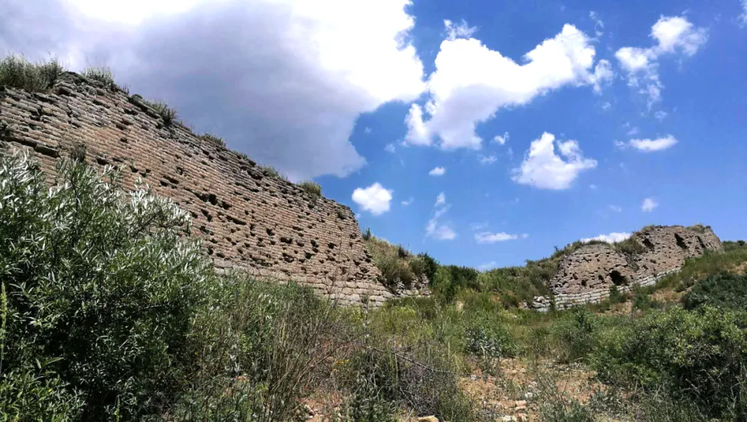
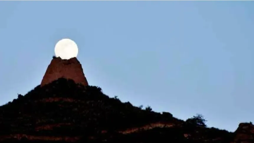
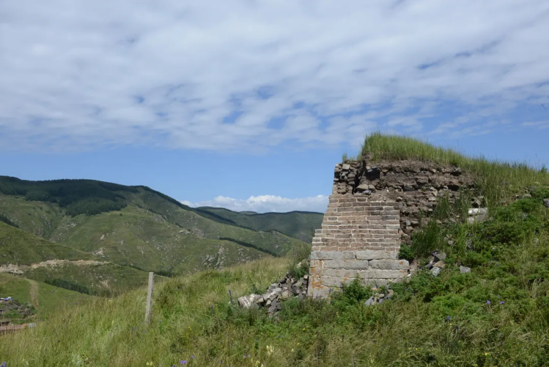
▲Hunyuan, Dachuangling Great Wall Photo by Tong Yongjiang
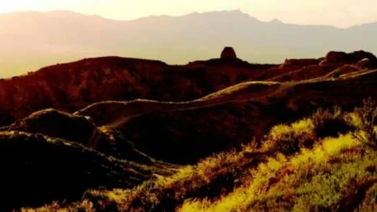
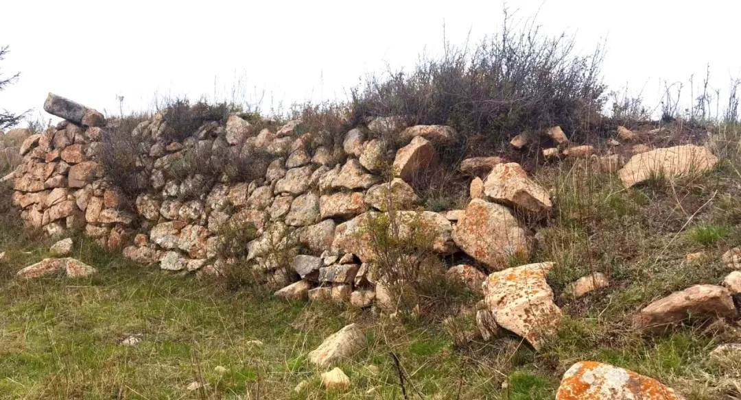
▲Hunyuan, Luozizhu Great Wall Photo by Cheng Tianyou
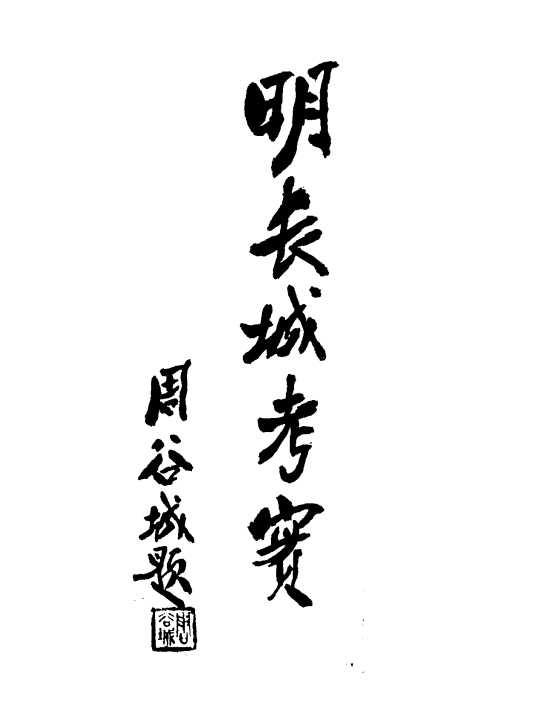
▲"A Study of the Ming Great Wall" Title by Zhou Gucheng
Ming Great Wall in Hunyuan and Fanshi Counties
Huaxiazi | Text
▲ "A Study of the Ming Great Wall" - Hunyuan and Fanshi County Great Wall
Hunyuan County Ming Great Wall
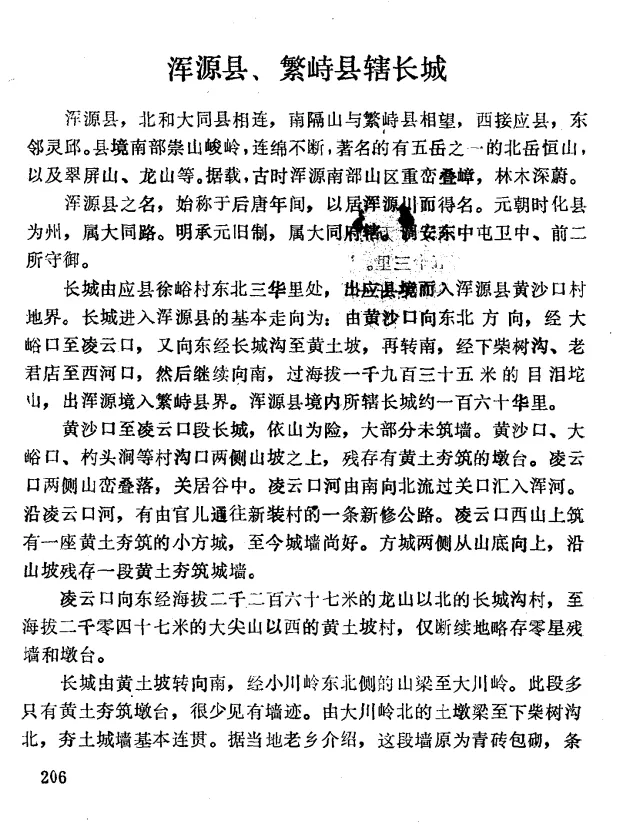
Hunyuan County borders Datong County to the north, Fanshi County to the south across the mountains, Ying County to the west, and Lingqiu County to the east. The southern part of the county is characterized by continuous, towering mountains, including Hengshan Mountain, one of the Five Great Mountains, as well as Cuiping Mountain and Longshan Mountain. Historically, the southern mountainous region of Hunyuan was known for its dense forests and towering peaks.
The name Hunyuan County originated in the Later Tang Dynasty, named after its location in the Hunyuan Valley. During the Yuan Dynasty, the county was upgraded to a prefecture, under the jurisdiction of Datong Road. The Ming Dynasty followed the Yuan Dynasty system, placing it under the jurisdiction of Datong Prefecture, and assigned the An Dong Zhongtun Guard's middle and front two battalions to defend it.
The Great Wall enters Hunyuan County from Ying County, starting from Xu Yu Village in the northeast, three li away. Its general direction within Hunyuan County is northeast from Huangshakou, passing through Dayukou to Lingyunkou, then east through Changchenggou to Huangtupo, then south through Xiachaoshugou, Laojundian to Xihekou, and further south, over the 1935-meter-high Muleituo Mountain, exiting Hunyuan and entering Fanshi County. The section of the Great Wall within Hunyuan County is approximately 160 li long.
The section of the Great Wall from Huangshakou to Lingyunkou utilizes natural mountain defenses, and much of it is not walled. On the slopes on both sides of the village and gully entrances such as Huangshakou, Dayukou, and Shaotoujian, remnants of rammed earth platforms remain. Lingyunkou is situated in a valley between overlapping mountains. The Lingyunkou River flows north through the pass into the Hun River. A newly built road runs along the Lingyunkou River, connecting Guan'er to Xinhuangcun. A small, rammed earth square city is built on the west mountain of Lingyunkou, with its walls still largely intact. On both sides of the square city, sections of rammed earth walls remain along the mountain slopes from the bottom upwards.
From Lingyunkou eastward, passing north of Longshan Mountain (2267 meters above sea level) in Changchenggou Village, to Huangtupo Village west of Dajianshan Mountain (2047 meters above sea level), only scattered remnants of walls and platforms remain.
The Great Wall turns south from Huangtupo, passing through the mountain ridge northeast of Xiaoqiaoling to Dachuanling. This section mostly consists of rammed earth platforms with few wall remains. From the earth mound ridge north of Dachuanling to the north of Xiachaoshugou, the rammed earth walls are largely continuous. According to local residents, this section was originally clad in blue bricks with a stone foundation, but it has all been demolished. There are indeed bricks from the Great Wall in Xiachaoshugou Village.
The Great Wall continues south from Xiachaoshugou Village along the mountain ridge to Zhenggou Village. There are remnants of a platform past Xiachaoshugou. Locals say this was originally a hollow enemy tower, with a stone base, brick construction, and a stone-framed arched gate with a stone plaque above the gate. On the wall section where this enemy tower is located, there are terraced retaining walls built by farmers during the "Learn from Dazhai" movement, using stones and broken bricks from the Great Wall enemy towers.
East of Zhenggou Village, the Great Wall descends south along the mountain ridge to a platform east of Donghulu Village, which only retains rammed earth. According to local residents, this section was originally built with a stone foundation and clad in blue bricks, but now only the rammed earth remains inside the walls.
Starting from the platform on the east mountain of Dong Hulu Tou Village, the Great Wall extends south to Shang Hua Ling Village. This section of the Great Wall has completely collapsed into piles. From the collapsed materials, it can be determined that the wall in this area was built of rammed earth, with rough stone cladding, and brick-built battlements. On the east mountain of Shang Hua Ling Village, there was a brick tower on the wall, but it has been demolished, leaving only the base, with stone at the bottom and brick at the top.
From the south mountain of Shang Hua Ling, the Great Wall turns north and then east to Lao Jun Shi on the north mountain of Lao Jun Dian. This section of the wall has completely collapsed, with a large number of broken stones and bricks scattered inside and outside the wall, occasionally with some intact bricks. Local villagers introduced that the wall in this area was built with a stone base and bricks, and the bricks and stones were demolished for civilian use in earlier years. West of Lao Jun Dian Village, there is a huge rock standing alone on a cliff, locally known as "Lao Jun Shi." A pavilion was originally built on it, but it was later demolished. There are still holes on the rock where the original pillars were embedded. Legend has it that this was where Lao Tzu practiced alchemy.
The Great Wall passes Lao Jun Dian and heads towards Hei Gou Bei Village, with no obvious traces left. After Ming Shi Jian Liang, a peak with an elevation of 2140 meters above sea level, in Hei Gou Bei, it turns east, then south to Xi He Kou, utilizing the natural mountain barriers, and in some sections, only simple stone walls were built.
The Great Wall descends from the foot of the north mountain of Xi He Kou to the mountain foot. Originally built with a stone base and brick cladding, it has now been demolished, leaving only remnants of rammed earth walls. On the top of the north mountain of Xi He Kou, there is a rammed earth enclosure. Today, the asphalt road from Hun Yuan County to Fan Shi County passes through Xi He Kou, with remnants of rammed earth walls on both sides of the road.
The Great Wall extends south from Xi He Kou to the east mountain of Xiao Niu Huan Village, with remaining rammed earth walls. From the east mountain of Xiao Niu Huan Village, the Great Wall continues south-east to Mu Lei Tuo Mountain. This section of the wall is extremely severely collapsed, and a section of rough stone wall on Mu Lei Tuo Mountain has also collapsed.
The watershed of Mu Lei Tuo Mountain is the boundary between Hun Yuan and Fan Shi counties. After passing Mu Lei Tuo Mountain, the Great Wall leaves Hun Yuan County and enters Fan Shi County.
Ming Dynasty Great Wall in Fan Shi County
Fan Shi County was Jianzhou during the Yuan Dynasty. During the Ming Dynasty, it belonged to Dai Prefecture. According to the "Ming History, Geography Section": "In the second year of Hongwu (1369 AD), it was changed to Fan Shi County, and in February of the eighth year, it came under the jurisdiction." "There were three patrol offices in the north at Ru Yue Kou, in the northeast at Bei Lou Kou, and in the east at Ping Xing Ling, which were later abolished."
The basic direction of the Great Wall within Fan Shi County is: from Tuan Cheng Kou southeast through Xi Pao Chi to Ping Xing Guan, from Ping Xing Guan south through Ma Pao Quan, San Ling, to Kao Bing Shan, with an elevation of 1831 meters. Continuing south, from Shen Tang Bao northeast direction, it extends into Niu Bang Kou in Ling Qiu County. The Great Wall within Fan Shi County is approximately 98 li long.
From Mu Lei Tuo Mountain east to Tuan Cheng Kou, the remaining walls and platform ruins are all made of rammed earth. According to local villagers, the platforms were originally brick-built, and later the bricks were demolished for civilian use. Today, the walls of the cave dwellings of the residents in Tuan Cheng Kou and other villages are mostly built using bricks from the Great Wall.
The Great Wall passes Tuan Cheng Kou southeast to Xi Pao Chi, basically relying on the natural mountain barriers without building walls. Rammed earth walls about three meters high are seen starting from the east mountain ridge of Xi Pao Chi. This section of the wall is built on the flat ridge between two peaks. There are four platforms in between, but only one still has some remaining stone cladding, the rest are all collapsed into rammed earth platforms. This section of the wall ends at the north side of a mountain peak, and rammed earth walls reappear on the south side of the peak, along the ridge to Ping Xing Guan.
Ping Xing Guan, originally named "Ping Xing Zhai," has always been an important military and transportation route. According to "Du Shi Fang Yu Ji Yao": "It controls Zi Jing in the east and Yan Men in the west, and is responsible for 124 li of the inner border together with Tuan Cheng Zi Bao. During the Jiajing period, bandits often invaded Fan Shi and Dai Zhou from here."
Ping Xing Guan is located on a gentle slope between two mountains. A small pass city was built at the pass, which is now ruined, with only scattered stone foundations remaining. A brick arched doorway still exists at the pass, with a plaque embedded above it, inscribed with the three characters "Ping Xing Guan." According to local villagers, a three-bay single-story gate tower was originally built on the gate city platform. The tower and gate were destroyed by floods in 1939. The current gate was rebuilt in 1962, with a new plaque embedded. Inside the gate, a protection stele for the "Ping Xing Guan Battle Site" erected by the government in 1965 is embedded on the north wall. On September 25, 1937, the 115th Division of the Eighth Route Army 685th, 686th, and 687th regiments fought against the invading Japanese army here, annihilating more than 1,000 soldiers of the 21st Brigade of the Itagaki Division. This battle was a major victory in China's War of Resistance.
Three li southwest of Ping Xing Guan, there is a Ping Xing Guan castle, now Ping Xing Guan Village, Heng Dong Gou Township, Fan Shi County. According to "Du Shi Fang Yu Ji Yao" quoting "Bian Fang Kao": "The castle was built in the sixth year of Zhengde (1511 AD), and was expanded in the 24th year of Jiajing (1545 AD) and the ninth year of Wanli (1581 AD), with a circumference of two li and some odd." The castle originally had a stone foundation and blue brick cladding. Now most of it has been demolished, leaving only rammed earth walls. Only the north gate and the outer city gate remain. The outer city gate opens to the east. A stone tablet is embedded in the east wall of the north gate, which was embedded when the brick-paved city top and the north gate outer city were built in the seventh year of Tianqi (1627 AD). The tablet is intact, and the inscription is clear. The Great Wall south of Ping Xing Guan mostly relies on natural mountain barriers. After passing Kao Bing Shan, there is a severely damaged section of the wall east of Zhong Er Si Village to the northeast of Shen Tang Yu Bao, ending on the west side of a mountain at the border of Fan Shi and Ling Qiu counties. The Great Wall reappears on the southeast side of the mountain in Ling Qiu territory, descending to Niu Bang Kou.
Five li south of Shen Tang Yu Bao is Ci Gou Ying Bao. Although damaged, Ci Gou Ying City is relatively well-preserved. There are gates on the east, west, and south sides. The east gate still has a brick arched doorway, with a stone plaque embedded above it, with the characters "Ying Guan Cheng" engraved on it. On the top of the north mountain, there is a brick-built hollow enemy tower, which is also well-preserved.
A Study of the Ming Great Wall
Ming Great Wall in Hunyuan and Fanshi Counties
2
3
4
Swipe left or right to view more
Introduction of the Main Author
Dong Yao Hui, born in 1957, is a native of Funing, Hebei. He is a renowned Great Wall expert and the executive vice president of the China Great Wall Society. He is also the director and professor of the Great Wall Research Institute of Hebei University of Geosciences, and the director of the Yan Shan University China Great Wall Culture Research and Dissemination Center.
For 40 years, Dong Yao Hui has been dedicated to the research and writing of the Great Wall, and has made significant contributions to its protection, maintenance, publicity, and development. In addition to "A Study of the Ming Great Wall", he has also authored more than ten monographs, including "Wa He Ji - Essays on Great Wall Research", "Guardian of the Great Wall - Dong Yao Hui Talks about Great Wall Protection", "The Great Wall: Questions and Resonance", "History of the Ming Dynasty Great Wall", and "Draft History of the Great Wall".

▲Distribution Map of Historical and Cultural Relics in Hunyuan County
Appendix 1
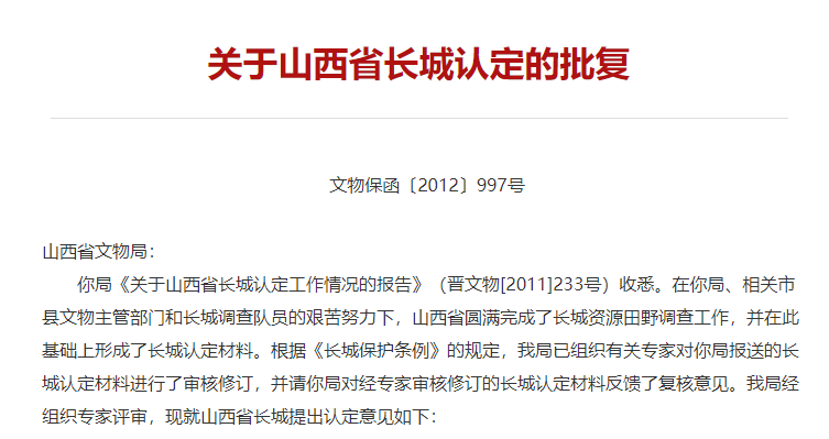
Document No. [2012] 997 on Cultural Relic Protection
Shanxi Provincial Cultural Relics Bureau:
Your bureau's "Report on the Identification of the Great Wall in Shanxi Province" (Jin Wenwu [2011] 233) has been received. Thanks to the arduous efforts of your bureau, the relevant municipal and county cultural relics authorities, and the Great Wall survey team, Shanxi Province has successfully completed the field survey of Great Wall resources and, on this basis, has compiled materials for the identification of the Great Wall. In accordance with the "Great Wall Protection Regulations", our bureau has organized relevant experts to review and revise the Great Wall identification materials submitted by your bureau, and has requested your bureau to provide feedback on the review opinions on the Great Wall identification materials that have been reviewed and revised by experts. After expert review by our bureau, the following opinions are put forward on the identification of the Great Wall in Shanxi Province:
1. The Great Wall in Shanxi Province is identified as being distributed in 39 counties, cities, and districts, including Great Wall sections and ancillary facilities built or used during the Warring States, Han, Northern Wei, Eastern Wei, Northern Qi, Sui, Five Dynasties, and Ming dynasties. Details are shown in the attached table. Among them:
Warring States Great Wall: Starting from Lingchuan County in the east, passing through Huguang County, and reaching Gaoping County in the west.
Han Great Wall: Starting from Tianzhen County in the east, passing through Zuoyun County, and reaching Youyu County in the west.
Northern Wei Great Wall: Distributed in Tianzhen County.
Eastern Wei Great Wall: Distributed in Ningwu County.
Northern Qi Great Wall: Divided into two lines. The first line starts from Guangling County in the east, passing through Hunyuan County, Ying County, Shanyin County, Daixian County, Yuanping City, Ningwu County, Shenchi County, Wuzhai County, and Kelan County, and reaching Xing County in the west; the second line starts from Zuoyun County in the east, passing through Pinglu District of Shuozhou City, and reaching Panguan County in the west. There is also a distribution in Zizhou County.
Sui Great Wall: Distributed in Kelan County.
Five Dynasties Great Wall: Distributed in Qinshui County.
Ming Outer Great Wall: Starting from Tianzhen County in the east, passing through Yanggao County, Datong County, Xiongru District, Urban Area, and Nanjiao District of Datong City, Zuoyun County, Youyu County, and Pinglu District of Shuozhou City, and reaching Hequ County in the west.
Ming Inner Great Wall: The first line starts from Lingqiu County in the east, passing through Guangling County, Hunyuan County, Huai'ren County, Ying County, Shanyin County, Fanshi County, Daixian County, Yuanping City, Shuozhou City's Shuozhou District, Ningwu County, and Shenchi County, and reaching Panguan County in the west; the second line starts from Lingqiu County in the north, passing through Wutai County, Yu County, Yangquan City's suburban area, Pingding County, Xiyang County, Heshu County, and Zuoquan County, and reaching Licheng County in the south.
2. In accordance with Article 9 of the "Great Wall Protection Regulations", the people's governments of provinces, autonomous regions, and municipalities directly under the Central Government where the Great Wall is located shall, within one year from the date of identification by the State Cultural Relics Administration, legally identify and announce the Great Wall already identified within their administrative regions as provincial-level cultural relics protection units. Please report to the Shanxi Provincial People's Government to legally announce the Great Wall that has been identified by our bureau but has not yet been identified and announced as a national key cultural relics protection unit or a provincial-level cultural relics protection unit as a provincial-level cultural relics protection unit, and delineate the protection scope, make markings and explanations, establish record archives, establish a special agency or assign a dedicated person to be responsible for management, and implement various basic work for Great Wall protection.
3. Sites and remains related to the Great Wall defense system (such as steles, residential sites, brick and tile kilns, quarries, and tombs of garrison soldiers), which have been registered and recorded through Great Wall resource surveys, are immovable cultural relics that carry important historical information. Please coordinate and urge the relevant local people's governments at all levels to further strengthen the research of related sites and remains, and in accordance with their historical, artistic, and scientific value, and in accordance with relevant laws and regulations such as the "Cultural Relics Protection Law of the People's Republic of China", announce them as cultural relics protection units of the corresponding level, and implement relevant protection and management work.
This is in reply.
State Administration of Cultural Heritage
May 14, 2012
▲Hunyuan·Luoziwa Great Wall Wu Cong Photo
Appendix 2
Friendly Tip: Click on the image to enlarge
1
Hunyuan County Ming Great Wall
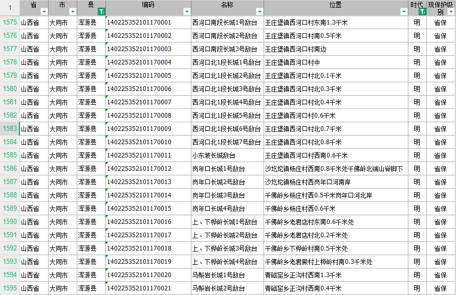
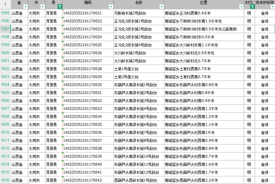
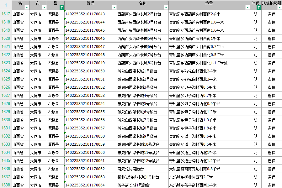
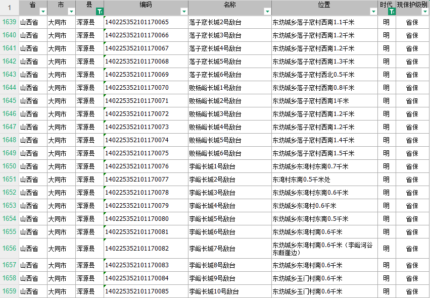

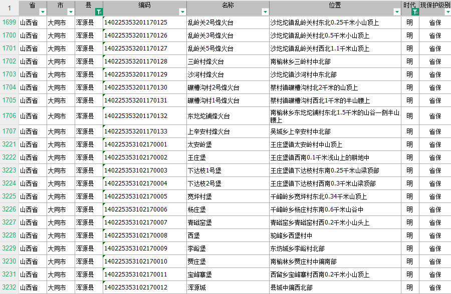
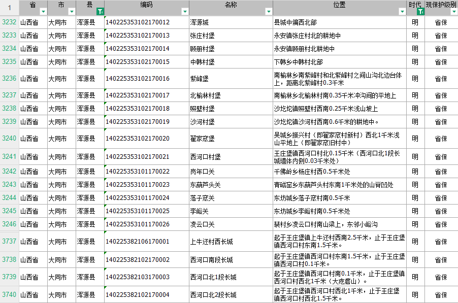
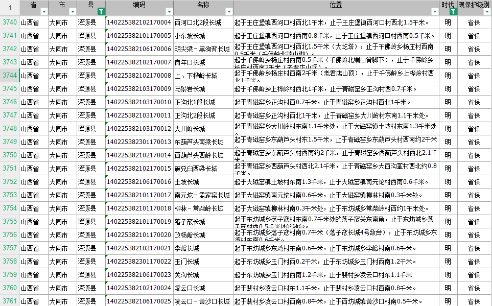
2
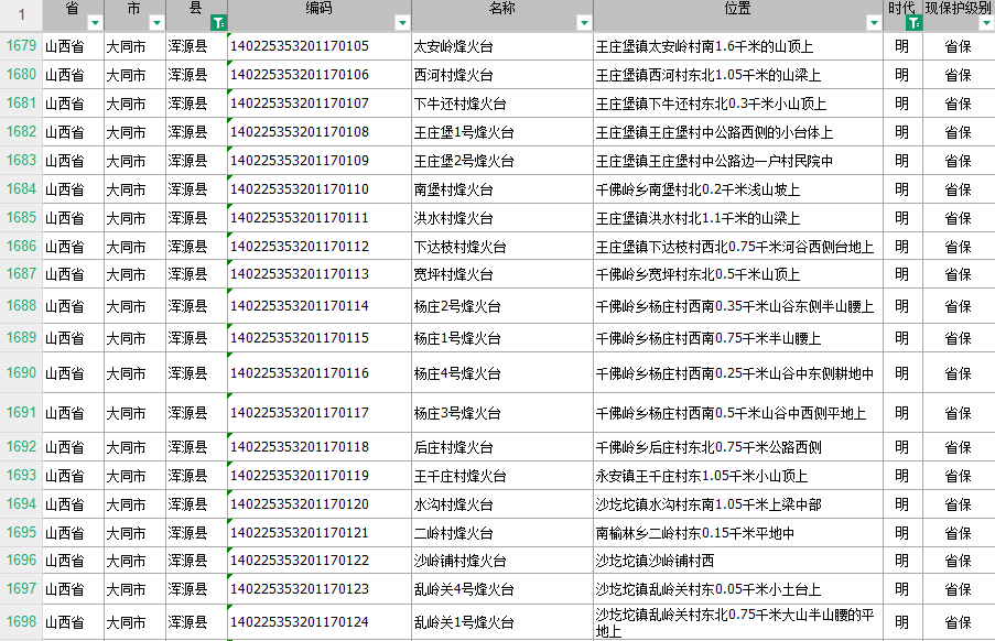
Hunyuan County Northern Qi Great Wall
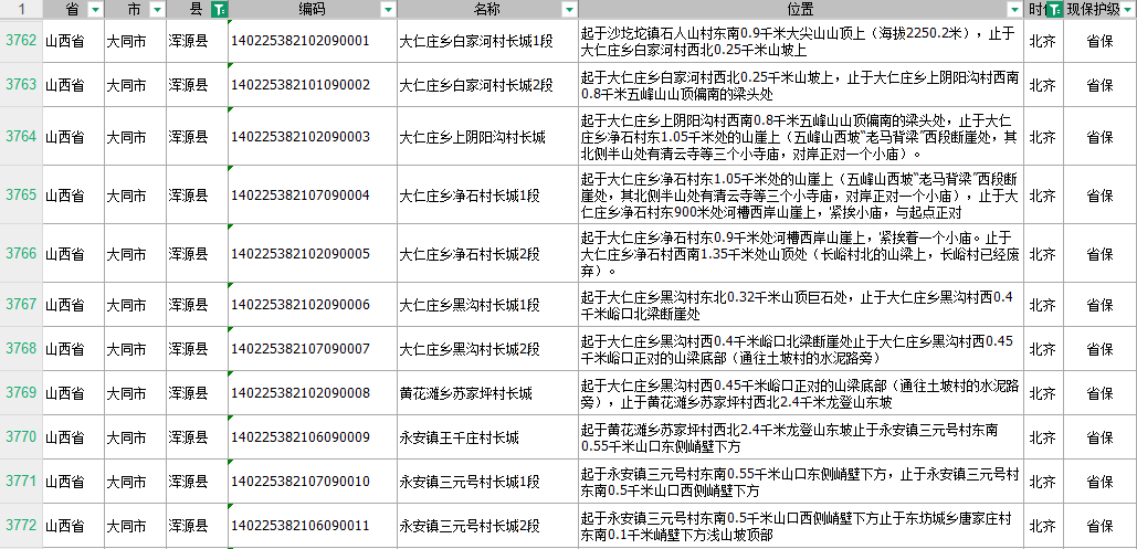
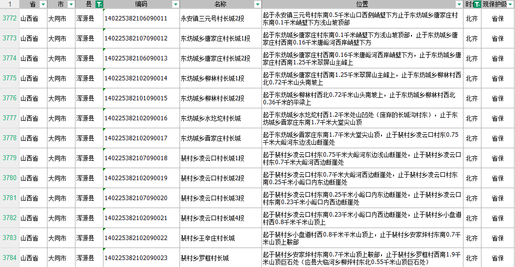
Data Source | State Administration of Cultural Heritage Website
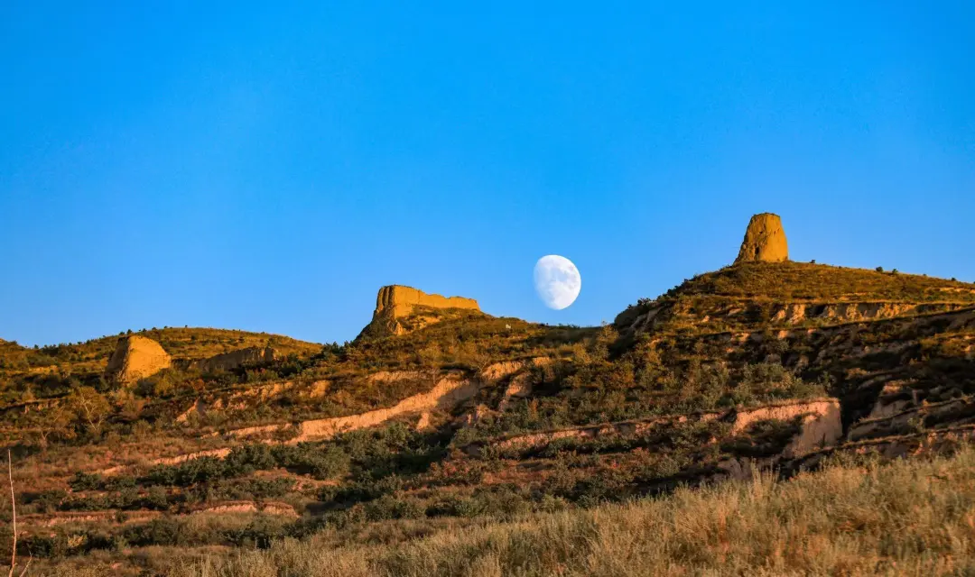
▲Hunyuan·Mazongya Great Wall Tong Yongjiang Photo
▲Hunyuan·Shangcun Town Great Wall Cheng Tianyou Photo
Proofread: Xuefang
Edited: Xuelin
Keywords:
Related News
Contact Us
Beiyue Hengshan Scenic Area:
Travel Inquiry:+86-352-8333077
Ticket Inquiry:+86-352-8333031
Travel Complaints:+86-352-8333081
Emergency Rescue:+86-352-8333037
Mount Hengshan Scenic Area Administration Center (Official)
+86-352-8322142
Hanging Temple
+86-352-8327795
Yuemenwan (Hengshan Mountain Gate)
+86-352-8480060 +86-352-8328318 +86-352-8328530
Hengzong
+86-352-8480115
Tianfeng Ridge
+86-352-8480114
Yong'an Temple
+86-352-8322390
Li's Family Cemetery
+86-352-8322381
Hengshan Cableway
+86-352-8322255
Official Media

Tiktok