

-
AboutMount Heng, an outstanding representative of the splendid mountains and rivers of China, a symbol of national prosperity, a totem of national spirit, an important geographical indication of the country, and holds the status of a national mountain.More
-
CultureHengshan has been a famous scenic spot and important birthplace of Taoism in northern China since ancient times. Carrying the symbols of Chinese civilization, it has nurtured profound regional culture and folk customs.More
-
-
Tourist GuideUnderstand relevant information about the scenic area and enjoy a better travel experience.More
-
Surrounding activitiesThe ancient city of Hunyuan at the foot of Mount Heng in Beiyue has a long history, rich cultural heritage, beautiful scenery, and a convergence of agriculture, commerce, and animal husbandry. It has nurtured a unique regional culture and is renowned for its fine wine and delicious food.More


Eleven Lectures on the History and Culture of Hengshan Mountain (Hunyuan)
Publish Time:
2025-03-14 18:11
Source:
As a native of Hunyuan, I have a duty to promote Hunyuan, integrating culture and tourism to enable tourists to understand and appreciate Hunyuan, thereby promoting the development of Hunyuan's cultural and tourism industry.
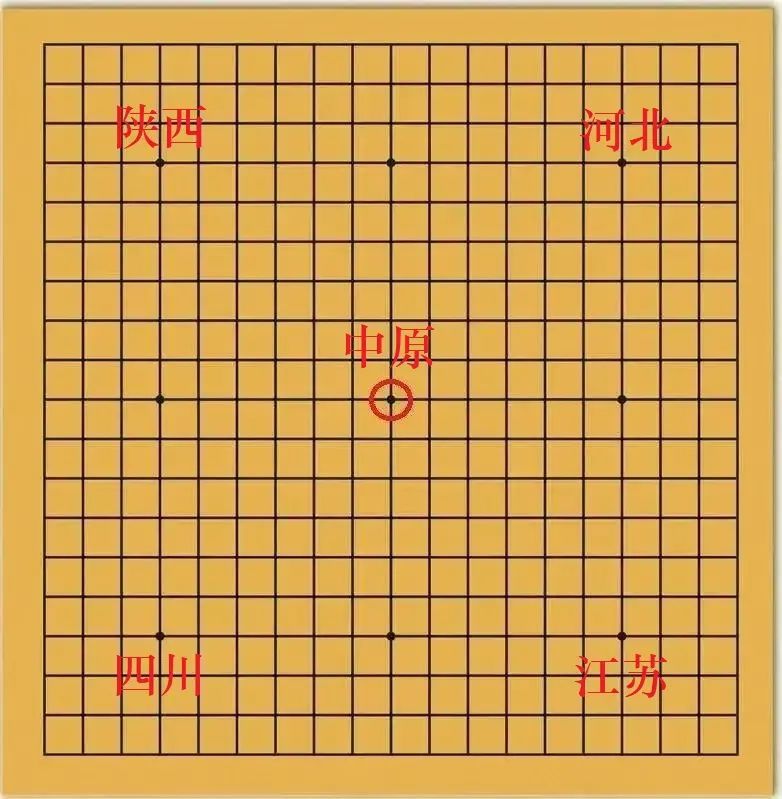
I. China's Geographical Pattern
Before understanding Hengshan Mountain, let's first understand China's geographical pattern.
Let me tell you a short story - "Gonggong angrily struck Mount Buzhou". Legend has it that during the time of the Three Sovereigns and Five Emperors, there were two tribes vying for control of the land. The leaders of these tribes were Gonggong and Zhuanxu (the Northern Yue Emperor). Gonggong's tribe was defeated, and in a fit of rage, he struck Mount Buzhou with his head. With a crash! He brought down Mount Buzhou. Mount Buzhou was a pillar supporting the heavens; with the pillar broken, the land became uneven. The sun, moon, and stars shifted, and the land began to sink towards the southeast, eventually forming the northwest-high, southeast-low terrain. The northwest consists of mountains thousands of meters high, while the southeast is either plains or the sea.
This is a short story from the Huainanzi. The story of "The Old Man Who Lost His Horse", which we learned in middle school, is also from this book, which is over 2000 years old. What conclusion can we draw from Gonggong striking Mount Buzhou? People 2000 years ago already had a general understanding of China's topography and geomorphology. Modern geography refers to this northwest-high, southeast-low terrain as the "three-level staircase of China's terrain".
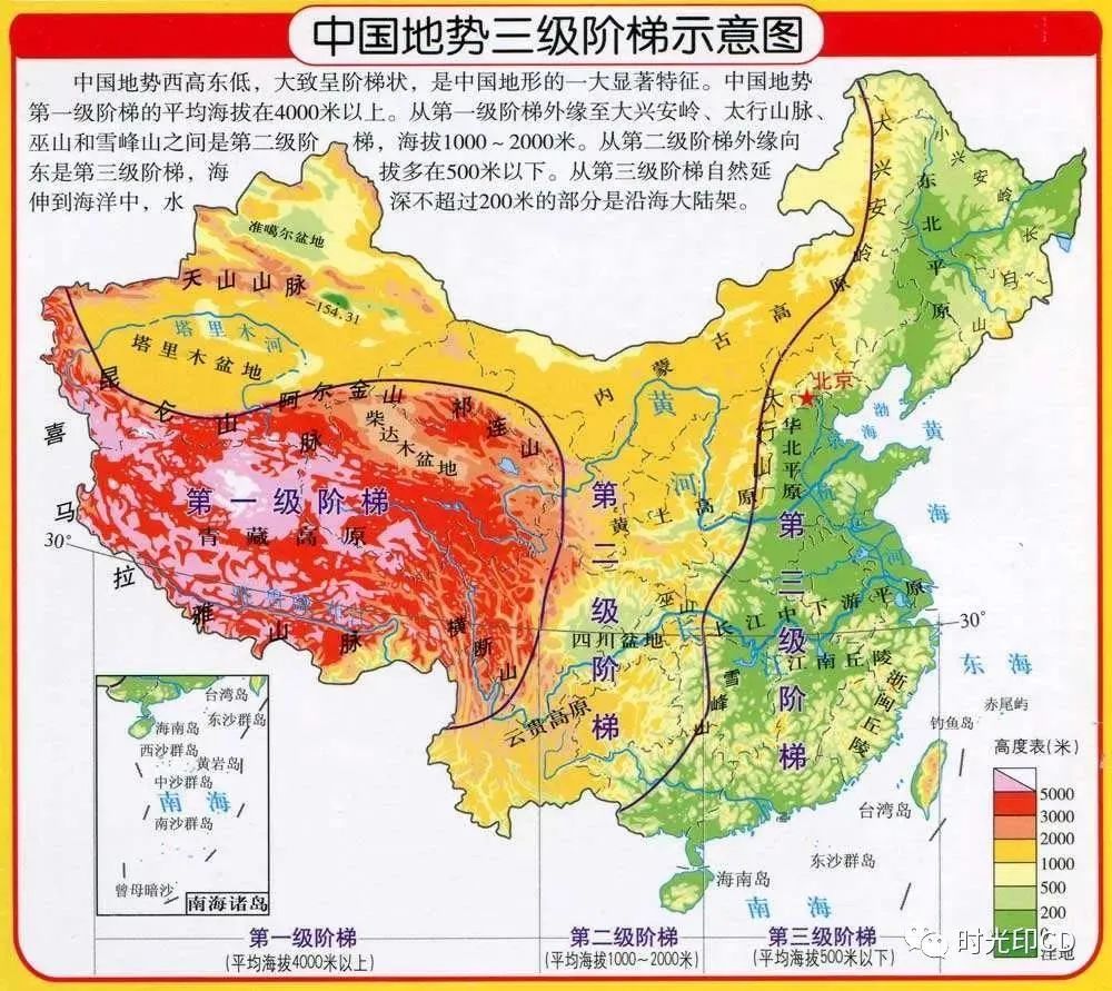
Let's look at this map. The first step has an average altitude of over 4000 meters, and is separated from the second step by the Kunlun Mountains, Altun Mountains, Qilian Mountains, and Hengduan Mountains. The area from the outer edge of the first step to the Greater Khingan Range, Taihang Mountains, Wushan Mountains, and Xuefeng Mountains is the second step, with altitudes between 1000 and 2000 meters. From the outer edge of the second step east to the sea is the third step, with altitudes mostly below 500 meters.
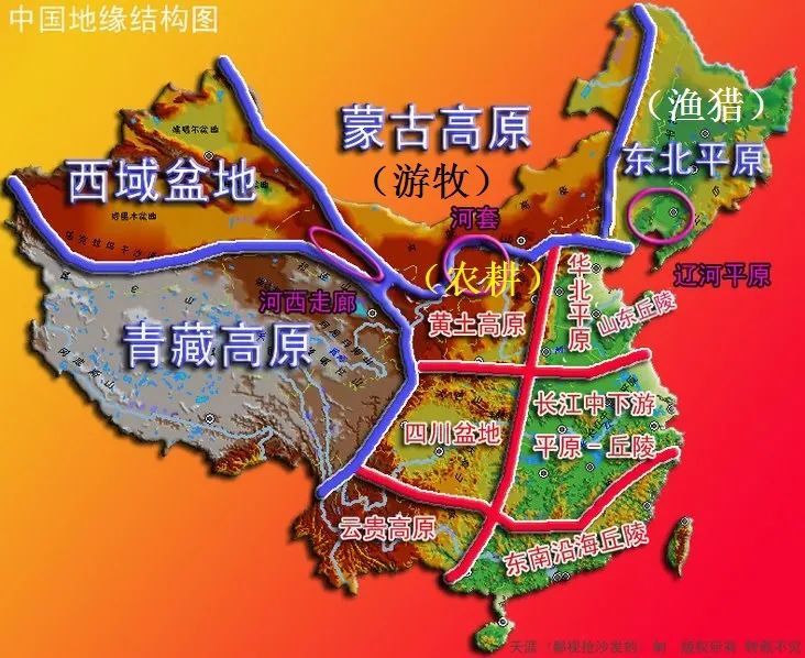
The second step includes the Inner Mongolia Plateau, Loess Plateau, Sichuan Basin, and Yunnan-Guizhou Plateau. Shanxi Province belongs to the Loess Plateau. North of the Loess Plateau is the Mongolian Plateau, east is the North China Plain, and northeast is the Northeast Plain. Let's look at the "China Geo-structural Map" and focus on the Mongolian Plateau and Northeast Plain.
II. The Geographical Pattern of the Mongolian Plateau
Historian Huang Renyu proposed the concept of the 15-inch isohyet, meaning that an area with an annual rainfall of 380 millimeters can be developed for agriculture.
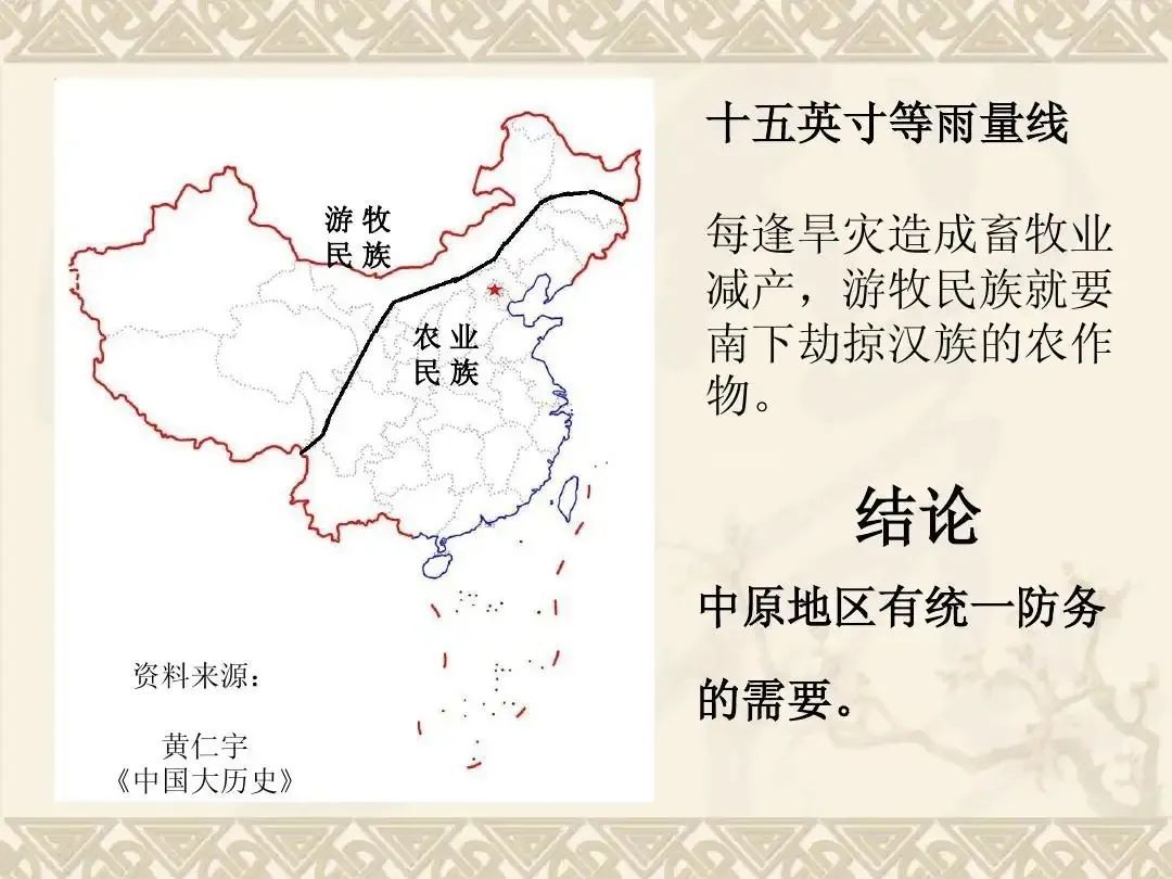
The Mongolian Plateau has an annual rainfall of less than 380 millimeters, making it more suitable for nomadic people. The Northeast Plain is near the sea and is affected by Pacific moisture, resulting in more rainfall. However, Heilongjiang and Jilin Provinces are located at higher latitudes and have cold climates. In ancient times, they were forested areas suitable for fishing and hunting. The Loess Plateau and North China Plain have annual rainfall exceeding 400 millimeters, making them suitable for agricultural development. Ancient people's ways of life were mainly based on farming, nomadism, and hunting and fishing. Of course, these three lifestyles were not fixed. Hunting and fishing people leaving the mountains and forests could easily become nomadic people. Nomadic people who moved into the Loess Plateau and North China Plain to cultivate land became farming people. A typical example is the Xianbei people, who originated from the Greater Khingan Range. They were originally a people who primarily hunted and fished. After moving south, they first became nomadic on the Mongolian Plateau, then entered the Loess Plateau, established their capital in Datong, then moved their capital to Luoyang, and became fully Sinicized, becoming members of the farming community.
Ancient people lived by the water, and this was true for farming, nomadic, and hunting and fishing peoples. Let's use the "Xiongnu Geo-structural Map" to analyze the geographical pattern of the Mongolian Plateau.
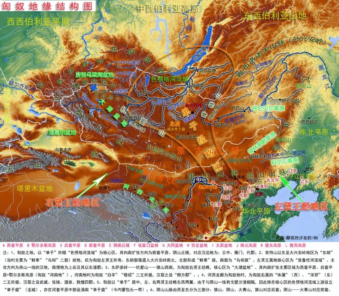
The Mongolian Plateau is not a flat expanse. Mountain ranges that run from west to east and dissect the Mongolian Plateau include the Altai Mountains, Hangai Mountains, Kentei Mountains, and Greater Khingan Range. These four mountain ranges divide the Mongolian Plateau into three parts: east, central, and west. The eastern part is located between the Greater Khingan Range and the Kentei Mountains. The main rivers are the Onon River and the Kherlen River, which belong to the upper reaches of the Heilongjiang River. During the Qin and Han dynasties, the eastern part of the Mongolian Plateau was controlled by the Left Xian Wang of the Xiongnu, who led raids south along the Hulunbuir and Xilin Gol grasslands, invading present-day Zhangjiakou and Beijing.
Between the Kentei Mountains and the Hangai Mountains lies the Selenga River basin, with major rivers including the Tuul River and Orkhon River, tributaries of the Selenga River. The Xiongnu Chanyu court and today's capital of Mongolia, Ulaanbaatar, were located on the Tuul River. During the Sui and Tang dynasties, the Turkic and Uyghur tribes, which successively dominated the Mongolian Plateau, and later the capital of the Mongol Empire, Karakorum, were all located in the Orkhon River valley. The Selenga River basin was a base of the Xiongnu, directly controlled by the Chanyu himself. At the same time, relying on the front Hetao Plain south of the Yin Mountains, they invaded Datong, Yamen Pass, and further south to Taiyuan, Luoyang, and even Xi'an.
The western part is enclosed by the Hangai Mountains, Altai Mountains, and Tannu-Ola Mountains, and is geographically known as the Great Lake Basin. The three largest inland lakes in the Great Lake Basin are Lake Khar Us Nuur, Lake Kyrgyz, and Lake Ubsa Nur, fed by the Kobdo River, Dzavkhan River, and Tes River respectively. The Great Lake Basin was controlled by the Right Xian Wang of the Xiongnu, whose direction of invasion was the rear Hetao Plain, the western Hetao Plain south of the Yin Mountains, the Ordos Plateau within the loop of the Yellow River, and the Hexi Corridor.
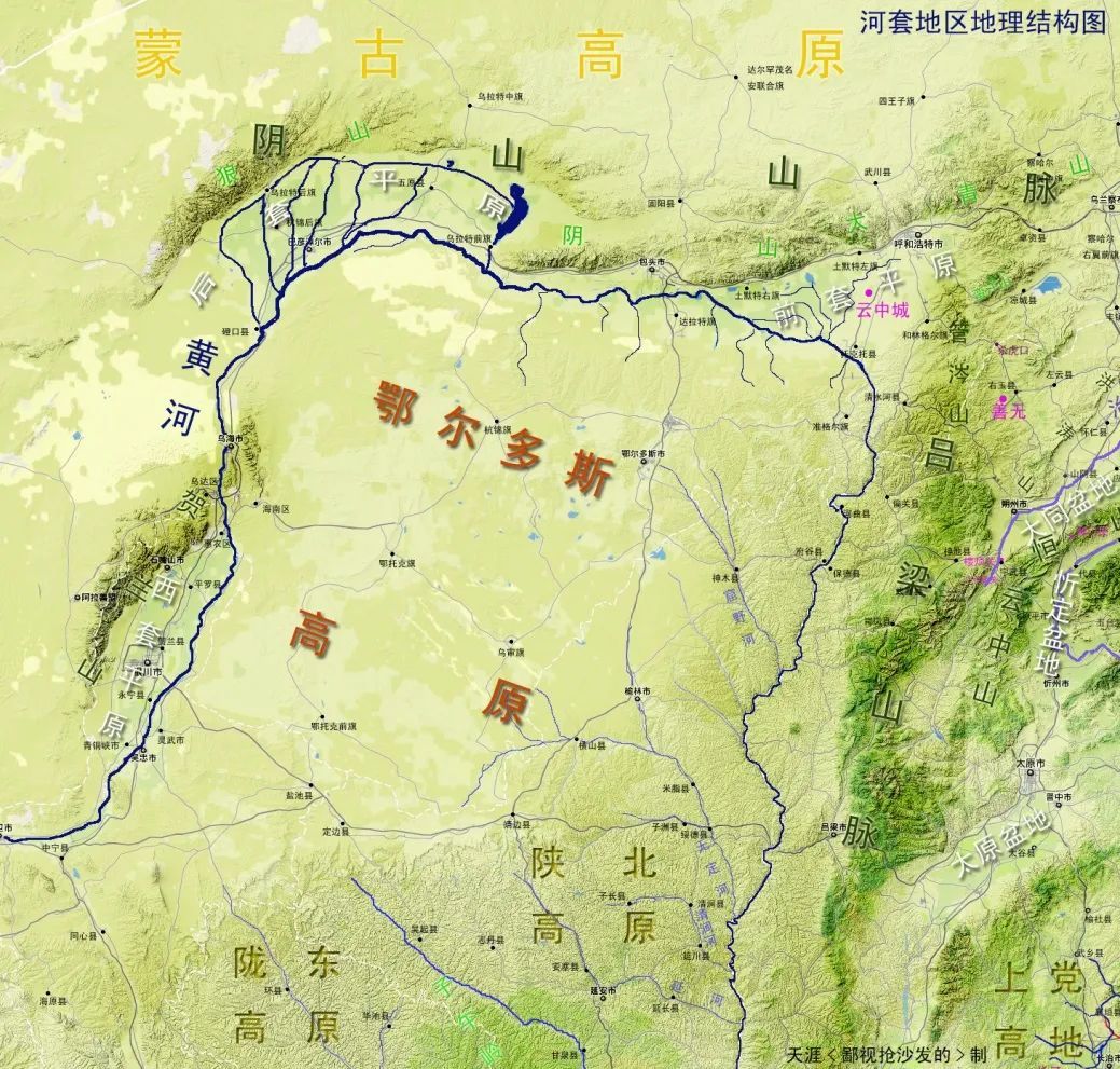
Let's look at the "Hetao Region Geographical Structure Map". Hetao refers to the loop area of the Yellow River. The front Hetao Plain roughly corresponds to present-day Hohhot and Baotou. The rear Hetao Plain roughly corresponds to Bayannur, and the western Hetao Plain roughly corresponds to Yinchuan. Hetao and the Shanxi Plateau, and indeed the entire Chinese nation, are closely related. The historical pattern is that when the central government is strong, it controls the Hetao region and builds the Great Wall along the Yin Mountains, thus repelling enemies from the country's borders. Conversely, when the central government is weak, the Hetao region is controlled by nomadic peoples, and Hebei, Shanxi, Shaanxi, Ningxia, and Gansu are never at peace. The government has to invest huge amounts of manpower and material resources to defend against the invasion of nomadic peoples. For example, in the middle and late Ming Dynasty, the Hetao was occupied by the Tatars, and Datong became the front line. Hunyuan was also frequently raided by the Tatars, hence the many villages named after forts.
Here I will explain the term "Going West". The people of Hunyuan refer to Youyu Shahu Pass as the "West Pass". Beyond Shahu Pass is the Helinger County of Inner Mongolia Autonomous Region. Shahu Pass is the boundary between Shanxi and Inner Mongolia. In addition to the West Pass, there is also an East Pass, Zhangjiakou, beyond which lies the Dameng grassland. The area north of the East Pass and West Pass is collectively known as "Outside the Passes." Outside the Passes, there is vast land but sparse population. When people of Shanxi suffered from disasters, going Outside the Passes was a choice they had to make.
The northwestern part of the Mongolian Plateau is mountainous, the southeastern part is a vast Gobi desert, and the central and eastern parts are large areas of hills. Influenced by Pacific Ocean moisture, rainfall gradually decreases from east to west. The area between the Kent Mountains and the Greater Khingan Range in the east receives the most rainfall, with annual totals reaching 300-400 mm. The famous Hulunbuir grassland is located in this area. Because of its rich water and grass, the Xiongnu Chanyu often used the crown prince as the Left Xian Wang to govern the east. Later, nomadic groups such as the Xianbei, Mongols, and Khitan also rose from the east, unified the Mongolian Plateau, and then rose to prominence in the Central Plains.
Having mentioned so many unfamiliar place names, I hope everyone has a general understanding of the surrounding environment of Shanxi. In ancient times, Shanxi faced the dual pressure of northern nomadic and fishing and hunting peoples, so from the Spring and Autumn period onwards, Shanxi was a melting pot of ethnic struggles and integration. Fishing and hunting peoples and nomadic peoples had relatively backward productivity, relying on the weather for their livelihood. Once a natural disaster struck, and they lacked food and clothing, they would go south to the Central Plains to 'beat the grass and get the valley' (打草谷). This term was coined by the Khitan people, meaning simply to plunder. If they didn't plunder, they couldn't survive. Faced with the threat of annihilation, they would not care about righteousness. I have a relative living in Wu Chuan, which is about 90 miles north of Hohhot and is under the jurisdiction of the Inner Mongolia Autonomous Region. The spring before last, he sent a video showing waist-deep snow, and him digging lambs out of snowdrifts. This is typical of Inner Mongolia; Outer Mongolia, which is even colder, needless to say. Historical records state that Su Wu herded sheep and lived by Lake Baikal for nineteen years, his integrity truly commendable.
Chairman Mao had a line, "The west wind brings down the fallen leaves to Chang'an, the whistling arrows fly." [Note: The ancients used wind to indicate the season. West wind represents autumn, east wind represents spring, south wind represents summer, and north wind represents winter. The whistling arrow is an arrow with a whistle.] Autumn is high, horses are fat, and arrows fly wildly. The nomadic peoples are about to invade, and we must be prepared. There is an old saying in Hunyuan: 'On the 15th of the seventh month, make offerings of noodles; on the 15th of the eighth month, kill the Tartars.' As soon as your grain harvest is plentiful, the Mongols will come to rob it. We must drive them away. Have you ever wondered why nomadic peoples always like to come to rob things in autumn?
Nomadic peoples prefer to invade in autumn and winter. Besides the fact that crops are not harvested in summer, another reason is that summer rainfall is frequent and the weather is humid. The nomadic peoples' daily necessities and military supplies are mainly made of leather. To use the Hunyuan dialect, "Once the leather gets damp, its quality deteriorates," and bows and arrows cannot function effectively. Therefore, they prefer to go south in autumn and winter to 'beat the grass and get the valley'. Farming peoples, on the other hand, typically choose to attack nomadic peoples in spring when there is a shortage of food, and horses, cattle, and sheep are underfed.
III. Geographical Pattern of the Shanxi Plateau
Let's look at the geographical pattern of the Shanxi Plateau. The mountains of Shanxi refer to the Taihang Mountains. Guo Lanying's song, "People say the Shanxi scenery is beautiful, the land is fertile, the water is beautiful, and the five grains are fragrant," and "pointing to the Taihang Mountains with the left hand and the Lüliang Mountains with the right hand," describes Shanxi's terrain. Let's take a look at the "Shanxi Topographic Map".
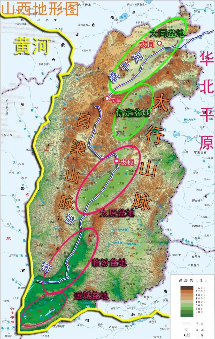
The terrain of Shanxi, simply put, is a series of basins nestled between two mountain ranges. The east and west sides are the north-south Taihang and Lüliang mountain ranges, and the Yellow River bends at the southeastern corner of Shanxi Province. I liken this geographical pattern to a natural city. The Taihang and Lüliang Mountains are the city walls, and the Yellow River is the moat, so the ancients often used the term "the inner and outer mountains and rivers" to describe Shanxi. This term comes from the Zuo Zhuan and has a history of over 2,500 years, demonstrating the ancients' understanding of Shanxi's topography.
Some comrades may have noticed that on the map, the Taihang Mountains are not on the right and the Lüliang Mountains are not on the left? North is up, south is down, west is left, and east is right. Teacher, why did you say, "pointing to the Taihang Mountains with the left hand and the Lüliang Mountains with the right hand?" Did you make a mistake? To clarify this issue, we must discuss how the ancients determined directions.
The ancient method of determining direction is the opposite of the direction on modern maps. A person faces south, the left hand is east, the right hand is west, the front is south, and the back is north. The book says that Xiang Yu was ashamed to face the elders of Jiangdong because the section of the Yangtze River from Wuhu to Nanjing is basically north-south. Jiangdong is the east side of the Yangtze River, also called Jiangzuo. Corresponding to Jiangzuo is Jiangyou, which is Jiangxi.
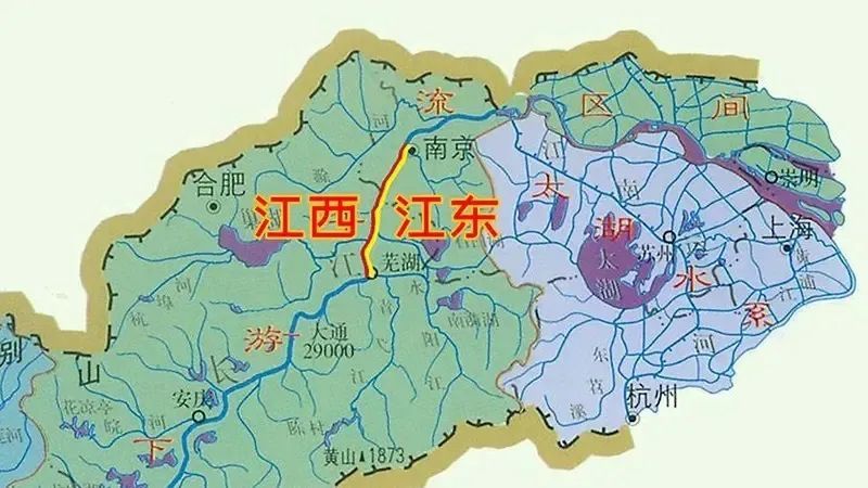
Henan and Hebei are also divided in this way. The Yellow River serves as the boundary, with Henan south of the Yellow River and Hebei north of it. Shanxi, before the Ming Dynasty, was called Hedong Dao because Shanxi was east of the Yellow River. Therefore, Shanxi and Hedong are the same place, and Jiangdong and Jiangnan are also the same region.
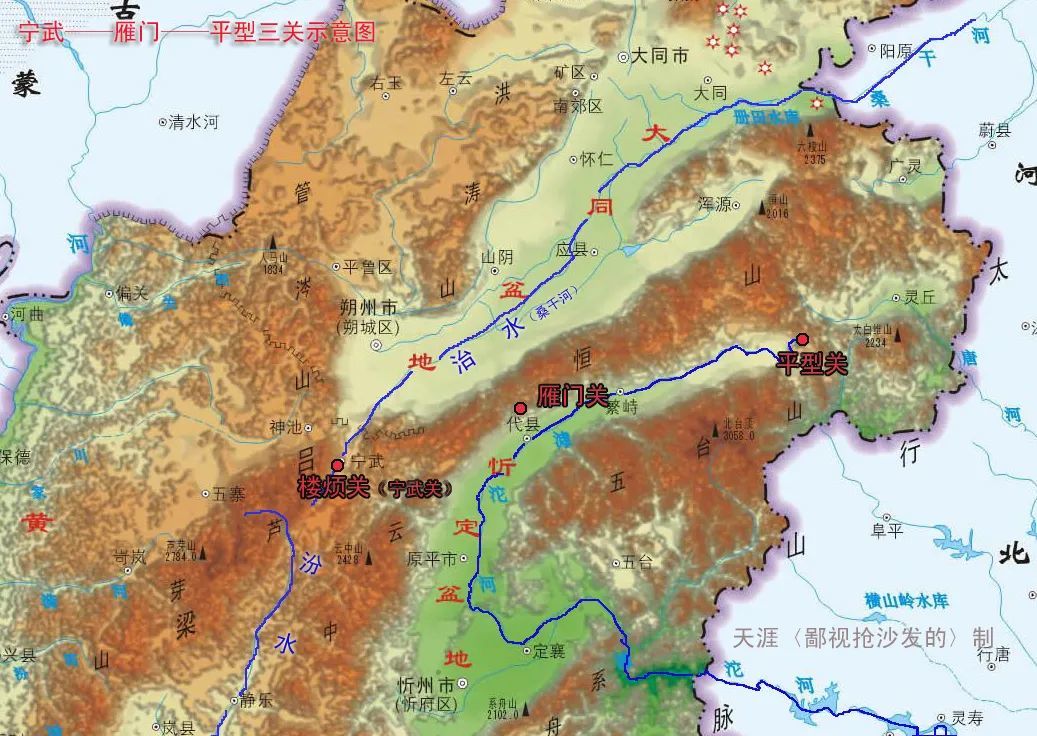
Let's continue to look at the "Shanxi Topographic Map." Several branches of the Taihang Mountains extend into the Loess Plateau, from north to south: Hengshan Mountain, Wutai Mountain, Xizhou Mountain, Taiyue Mountain, and Zhongtiao Mountain. These branches divide Shanxi Province into a string of pearl-like basins, from north to south: Datong Basin, Xinding Basin, Taiyuan Basin, Changzhi Basin, Linfen Basin, and Yuncheng Basin. The northernmost Hengshan Mountain range extends from Zhangjiakou City, Hebei Province in the east to Ningwu County, Xinzhou City in the west, connecting with the Guancen Mountains, stretching over 500 li. It is both the watershed of the Sanggan River and the Hutuo River, and the natural boundary between the Datong Basin and the Xinding Basin. In the age of cold weapons, nomadic peoples on horseback came from the Mongolian Plateau. Once the Datong Basin was lost, the Hengshan Mountain range became the last line of defense for the Han people, so the geographical location of Hengshan Mountain is crucial. Ningwu Pass, Yanmen Pass, Pingxing Pass, and our Hunyuan's Ciyao Town, all located along Hengshan Mountain, are important passes. During the Ming Dynasty, nine border towns were established, and Shanxi occupied two, Datong Town and Shanxi Town. The Inner Great Wall was also built along the Hengshan Mountain range.
IV. Geographical Pattern of Hunyuan and Hengshan Mountain
Let's go from big to small, first China, then Shanxi, then the geographical pattern of Hunyuan and Hengshan Mountain.
Hunyuan is located at the southeastern edge of the Datong Basin, and the Hengshan Mountain range runs through the entire region. [Note: The ancients used north-south as vertical and east-west as horizontal] . The geographical pattern of Hunyuan is "mountains to the south, slopes to the north, and a plain in between." The mountains to the south refer to Hengshan Mountain, the slopes to the north refer to Wucheng, Erling, Sanling, Dianshan, Matoushan, and Longshoushan, and the plain in between includes the Hunyuan county seat.
See the "Ningwu-Yanmen-Pingxing Three Passes Schematic Diagram".
Four relatively large rivers originate around Hengshan Mountain. One is the Hun River, formed by the confluence of several rivers including Wangqianzhuangyu, Tangyu River, and Lingyunkouyu. It flows from east to west, enters Yingxian County, then turns north along Longshou Mountain, and joins the Sanggan River at Xinqiao Village in Huai'ren. Another is the Huliu River, originating from Shiren Mountain on the border of Hunyuan and Guangling. It flows from east to west through Guangling, Weixian, and Yangyuan counties before joining the Sanggan River at Qianjiashawa Village. Both the Hun River and the Huliu River are first-level tributaries of the Sanggan River. As we all know, the lower reaches of the Sanggan River is called the Yongding River, the mother river of the people of Beijing. Therefore, if the ecological environment of Hengshan Mountain is not protected, the impact will not only be on Hunyuan, Guangling, and Yingxian, but also the capital city.
The other two rivers are the Tang River and the Hutuo River. The Tang River originates from Qiangfengling on the southern slope of Hengshan Mountain. It flows from north to south through Wangzhuangbao Town, and exits Shanxi Province at Beiqun Village in Lingqiu County, before flowing into Baiyangdian in Baoding City, Hebei Province. The Hutuo River originates from Qiaergou Village in Fanshi County, where the Taihang, Wutai, and Hengshan mountain ranges meet. It flows from east to west through Daixian and Yuanping, turns east at Dingxiang, and exits Shanxi Province through Wutai and Yu County into Hebei. If the Yongding River is the mother river of the people of Beijing, then the Hutuo River, which flows through Shijiazhuang and Zhengding, is the mother river of the people of Hebei. Therefore, as President Xi said, lucid waters and lush mountains are invaluable assets. Hengshan Mountain is not only militarily important, but its ecological environment is also crucial for Hebei and Beijing; its ecological system is closely interconnected.
For the whole Datong city, the annual rainfall barely meets the needs of agriculture; in some areas, the annual rainfall is less than 380 mm. The ecological environment is very fragile, and vigorously developing the tourism industry is the best choice. In 2022, the Hunyuan County Committee and the County Government proposed the development guideline of "promoting cultural ecology, pursuing tourism and health, and building a characteristic leisure city." For Hunyuan, developing agriculture, tourism, services, and processing industries are all correct directions.
To summarize the geographical pattern of Hengshan Mountain, it can be described as "Three Passes and Four Rivers." The three passes are Ningwu Pass, Yanmen Pass, and Pingxing Pass. The four rivers are the Hun River, the Huliu River, the Tang River, and the Hutuo River. The geographical pattern of the three passes and four rivers determines the prominent position of the Hengshan Mountain range in Chinese history.
V. Relationship between geographical pattern and administrative divisions
Next, let's discuss the relationship between geographical pattern and administrative divisions.
Mountains serve to divide different geographical units, while rivers connect them. Taking Hunyuan as an example, let's analyze the relationship between geographical pattern and administrative divisions.
Hunyuan is bordered by Guangling to the east at the Guanling Pass, which is the watershed between the Hun River and the Huliu River; to the north, it is bordered by Yunzhou at Dianshan; the southern boundary is more special, bordered by Lingqiu at Wangzhuangbao Town, but before the Liao Dynasty, Hunyuan and Lingqiu were divided by Qiangfengling, which is the watershed between the Tangyu River and the Tang River. The western part of Hunyuan is an open plain without obvious boundaries, but the boundary between Hunyuan and Yingxian will not exceed the Zhenziliang Reservoir at the end of Longshou Mountain; currently, it borders Yingxian at Xiaoxinzhuang Village.
Places with "Town" in their names mostly had a military nature in ancient times and were also important transportation hubs. For example, Tianzhen was the location of Tiancheng Army during the Tang Dynasty, hence its name. Hunyuan has Sagetuotuo Town in the east, Qingciyao Town and Wangzhuangbao Town in the south, Xifangcheng Town in the west, and Caicun Town in the north, which correspond to the four exits of Hunyuan. Of course, the roads leading out of Hunyuan are definitely more than four, but the roads through these five towns are traditionally "official roads," maintained by designated personnel, suitable for carriages and horses. During the Anti-Japanese War, the Japanese army set up strongholds in Guanling Pass, Qiangfengling, Qingciyao, Lingyunkou, and Songshuwang, indicating that these places were all passages in and out of Hunyuan.
Let's talk specifically about the route from Songshuwang to the Wengchengkou of Yunzhou District. After the completion of the S203 (Daling) line in 1971, the route from Songshuwang to Wengchengkou gradually fell into disuse. Today, the villages along the way are deserted. However, from the Ming Dynasty to the founding of the People's Republic of China, the route from Songshuwang to Wengchengkou was used as an official road. The fact that the Japanese set up strongholds and collected grain in Songshuwang clearly shows that Songshuwang was an important node on the transportation line.
Ancient people lived and migrated along rivers, and the advantage of migrating along rivers is that fresh water can be obtained at any time. At the same time, rivers are pioneers of nature; opening roads along rivers has twice the result with half the effort. Consider the road from Hunyuan to Lingqiu: starting from Hunyuan County, traveling south along the Tangyu River, crossing Qiangfengling, the watershed between the Tangyu River and the Tang River, entering the Tang River basin, and then reaching Lingqiu, Hebei, and even further places along the route developed along the Tang River. Ancient people mastered and applied these principles perfectly. The Northern Wei Dynasty's Dingzhou Avenue ran from Datong to Hunyuan, then to Lingqiu, and finally to Dingzhou in Hebei. Teacher Li, according to the "Book of Wei," recorded that the Northern Wei emperors went to Hunyuan for hunting, sightseeing, leisure, tourism, vacation, and hot springs at least 17 times. Emperor Xiaowen Tuobahong came the most, a total of seven times. When the Northern Wei royal family came to Hunyuan, they would often "inquire about the people's suffering and give palace women to poor people without wives." This is the origin of the many beautiful women in our Hunyuan. This shows that as early as 1500 years ago, Hunyuan was an important node on the transportation line between Datong and Hebei. [Note: The literature on the Northern Wei royal family's visits to Hunyuan will be provided after class; only two pieces of information about the royal family giving palace women will be listed in class.]
Volume 7, Gaozu's Records, Part 1:
In February, Dinghai year of Taihe 2 (478 AD), (Emperor Xiaowen) went to the hot springs in Dai (prefecture) (the hot springs in Tangtou Village, Wangzhuangbao Town, Hunyuan County, which had a hot springs palace during the Northern Wei Dynasty), inquiring about the suffering of the people along the way and giving palace women to poor people without wives.
In February, Xinsi year of Taihe 3 (479 AD), (Emperor Xiaowen) and the Empress Dowager (Empress Feng) visited the hot springs in Dai prefecture, inquiring about the people's suffering and giving palace women as wives to poor widows.
Implementing administrative divisions based on geographical patterns, mountain shapes, and water flow is known as "Shanchuan Xingbian." In ancient times, transportation was inconvenient, with a daily journey of only a few dozen miles. "Shanchuan Xingbian" facilitated government administration, but the disadvantage was that independent geographical units easily formed separatist regimes. Scholars studying military geography use the Go terms "golden corner, silver edge, and grass belly" to describe China's geographical pattern.
Jin Jiao roughly corresponds to present-day Hebei, Shaanxi, Sichuan, and Jiangsu provinces; Yin Bian roughly corresponds to present-day Shanxi, Hubei, and Shandong provinces; and Cao Du Pi refers to the Central Plains region, roughly corresponding to present-day Henan province. During times of turmoil, warlords used Jin Jiao and Yin Bian as their bases, forming separatist regimes and vying for control of the Central Plains. I sometimes joke with friends that Shanxi should thank not only Liang Sicheng and Lin Huiyin, but also warlords like Yan Xishan. Without their painstaking efforts, Shanxi might not have preserved as many historical relics as it does today.
Let's summarize the content discussed earlier. Many maps were used to help you view Shanxi, Hengshan Mountain, and Hunyuan, and their surrounding geographical units from a broader perspective. I have discussed five points, from large to small: 1. China's geographical pattern; 2. The geographical pattern of the Mongolian Plateau; 3. The geographical pattern of the Shanxi Plateau; 4. The geographical pattern of Hunyuan and Hengshan Mountain; 5. The relationship between geographical pattern and administrative divisions. With a basic understanding of geography, we can now explore the history and culture of Hunyuan.
As a side note, history and geography are inseparable. The study of history and culture, and the development of tourism, cannot be separated from the study of geography. Hunyuan was called Azhou County during the Han and Wei-Jin dynasties, but during the Sui and Tang dynasties, Yuanping also had an Azhou County, now called Aoyang Town. Many Azhou counties, which one is Hunyuan? Many local history scholars are unclear. However, as long as you grasp the law of "mountain and river shapes", all problems will be easily solved. Because historically, Hunyuan County's jurisdiction never included the area south of the Hengshan Mountain range, which is now Fanshi, Daixian, and Yuanping. By understanding the laws of history and geography, and by organizing the literature in chronological and geographical order, the historical evolution of Hunyuan becomes clear. Our Hunyuan's Li Yu Mei, a great man skilled in river management and revered as the River God, was adept at his work due to his extensive knowledge of history and geography. The ancients placed great importance on geographical knowledge. The Zhou Li records that the Western Zhou dynasty, three thousand years ago, established the post of Zhifangshi, responsible for maps of the world and important mountain passes. During the Ming and Qing dynasties, the Ministry of War had a Zhifang Langzhong with the same function. Li Yu Mei served as a minister of the Ministry of War, so he must have been familiar with geography, and his professional skills were superb.
VI. The Dai State and the Liyu Bronze Ware
Let me tell you another story from the Records of the Grand Historian, "The Hengshan Mountain Treasure Hunt".
During the Spring and Autumn period, Zhao Jianzi, the chief minister of the Jin state, was old and wanted to choose a successor. He summoned his sons and told them: "I have hidden a treasure on Hengshan Mountain. Whoever finds it first will be rewarded." The sons climbed Hengshan Mountain and searched for a long time, but found nothing. Only Zhao Xiangzi returned and reported: "Father, I have found the treasure." Zhao Jianzi said: "Where? Let me see it." Zhao Xiangzi replied: "Occupying Hengshan Mountain can allow us to annex the Dai state." Zhao Jianzi was overjoyed: "Good son, you have a keen eye. You will be my successor."
At that time, our Hunyuan was under the rule of the Dai state, and south of the Yanguan Pass was the territory of the Jin state. The king of the Dai state was Zhao Jianzi's son-in-law and Zhao Xiangzi's brother-in-law. Years later, Zhao Jianzi passed away, and Zhao Xiangzi went to inform his sister's family of the funeral, meeting his brother-in-law at the border between the two states, Yanguan Pass. While dining together, Zhao Xiangzi instructed the cook to kill his brother-in-law with a spoon. He then led his troops to attack the Dai state. Seeing her country destroyed and her family ruined, Zhao Xiangzi's sister was overcome with grief. She pulled out the hairpin from her hair, sharpened it on a stone, and stabbed herself in the throat, dying a tragic death. The people of the Dai state sympathized with her plight and renamed the mountain where she sharpened her hairpin "Moji Mountain".
Let's look at the "Diagram of the Geopolitical Relationships of Zhao, Yan, and Zhongshan States." During the Spring and Autumn period, there were four states around the Taihang Mountains: Jin and Zhongshan states to the south, and Dai and Yan states to the north. The Jin and Yan states were relatively strong and continuously expanded along both sides of the Taihang Mountains. Jin expanded from south to north, and Yan expanded from north to south. Dai and Zhongshan were sandwiched between the two powerful states of Yan and Zhao, which was very difficult. Of course, Dai and Zhongshan also had their moments of strength. To win over the Dai state, Zhao Jianzi married his daughter to the king of Dai. The bronze ware unearthed in Liyu, Hunyuan, has both Jin and Yan styles, and the academic community still has no conclusion about which state it belongs to. From a geographical point of view, the presence of Jin and Yan bronze ware in Liyu's unearthed artifacts is perfectly normal. Therefore, I personally believe that the Liyu bronze ware should belong to the Dai state, while the bronze ware of the Jin and Yan states are present due to diplomacy and marriage. [Note: The reason I say Jin and not Zhao is because the Dai state was destroyed in 475 BC, before Han, Zhao, and Wei had yet divided the Jin state. The map labels Jin as Zhao, which can be ignored]
In addition to the Liyu bronze ware, some Warring States period currency was also discovered in Dawa Village in the 1980s. Dawa and Liyu Dongwan, one on the north slope and one on the south slope, are both at higher altitudes than Chuan Di Xia. Judging from the location of the unearthed artifacts, people's activities were mainly concentrated in the hilly areas near the mountains. The Yuan Shi records that Hunyuan County suffered repeated floods, which inundated the homes of the people. The Wei Shu records that Emperor Taiwu Tuoba Tao once hunted tigers in Hunyuan. Tigers are typical forest animals, indicating that the ancient ecological environment of Hunyuan was much better than it is now.
Both the Dai and Zhongshan states were established by the northern Di people. After Zhao Jianzi annexed the Dai state, he still faced pressure from both the north and south, and his rule was unstable. Until the mid-Warring States period, Zhao Wuling Wang crossed the Hengshan Mountain range, expanded his territory, defeated the Linhu and Loufan tribes in the north, and extended his territory to the Yinshan Mountains. He established Yunzhong, Yanguan, and Daigun prefectures in the north of the Zhao state, thus incorporating the Datong Basin and the Hetao Plain into the territory of the Huaxia people.
Let's look at the "Map of Geopolitical Relations in the Three Northern Counties of Zhao". Yuncheng County controlled the Hetao Plain, with its county seat in what is now northwest of Helinger County, Inner Mongolia Autonomous Region; Yanmen County controlled the upper reaches of the Sanggan River, including present-day Shuozhou City, Datong City, and Fengzhen City, Inner Mongolia, with its county seat in present-day Youyu County, Shuozhou City, which could simultaneously control Shahu Pass; Dai County controlled the middle reaches of the Sanggan River, with its county seat in present-day Dai Wangcheng Town, Uixian County, Hebei Province. Dai Wangcheng was the capital of the Dai Kingdom during the Spring and Autumn Period, and there is a famous transportation route in Chinese history to its south - Feihuxiao. Going south from Feihuxiao, across Taihang Mountain, one can directly reach the hinterland of the North China Plain. Throughout history, countless battles have taken place on both sides of Feihuxiao. In January of the third year of Yongxi (986) in the Northern Song Dynasty, the Song army launched a northern expedition in three routes, and the central army broke through Feihuxiao, arriving in Uixian County via Laixian County to attack Khitan. Other battles in other years will not be listed.
VII. The Initial Establishment of Hailing County and the Former City of Hailing County
Hunyuan was called Hailing County in the Han Dynasty. We will continue our research into when the county was established and where its county seat was located.
During the Warring States period, after Zhao Wuling King set up Yanmen County, the present-day Hunyuan area belonged to Yanmen County, and Guangling belonged to Dai County. The boundary between Yanmen County and Dai County was the Luanling Pass in present-day Shagetuo Town. However, there is no clear record in the literature on whether Hunyuan County was established at that time. When Qin Shi Huang unified the country, he divided the country into 36 counties, but the rule of Yanmen County lasted only 15 years, and it is impossible to know the situation of Hunyuan at that time.
In the early Western Han Dynasty, the Xiongnu were strong, with the Chanyu residing in the center and the Left and Right Xian Kings residing in the east and west wings. Yuncheng, Yanmen, and Dai counties became the strategic area of the Chanyu's main force and were frequently invaded. During the reigns of Emperor Gaozu of Han, Emperor Wen of Han, and Emperor Jing of Han, the main diplomatic policy towards the Xiongnu was peace; militarily, relying on the Hengshan Mountain range, defenses were deployed along the line of Feihukou, Yanmen Pass, and Ningwu Pass to resist Xiongnu invasion.
In the early Han Dynasty, since the central government was unable to effectively control Yuncheng, Yanmen, and Dai counties, there is not much significance in exploring whether the central government had set up a county in Hunyuan. After Emperor Wu of Han ascended the throne, he began to launch a large-scale counterattack against the Xiongnu. In the second year of Yuanshou (127 BC), Wei Qing led tens of thousands of Han troops westward from Yuncheng County, attacking the Loufan and Baiyang tribes of the Xiongnu along the meandering Yellow River, and successively recovered the areas of Houtao and Xitao. This is known in history as the "Henan Battle".
After the Henan Battle, the Western Han Empire pushed its defense line to the Yinshan Mountain Range. Based on this, it is speculated that the establishment of Hunyuan County should be after the Henan Battle, that is, after 127 BC. According to the records in "Hanshu Geography", in the second year of Yuan Shi (AD 2) of Emperor Ping of Han, Yanmen County governed 14 counties, with 73,138 households and 293,454 people. Hunyuan has always been a county with a large population. According to the average, 290,000 divided by 14, each county has more than 20,000 people. Therefore, I believe that the Western Han Dynasty was the first peak period of large-scale development of Hunyuan by the central government.
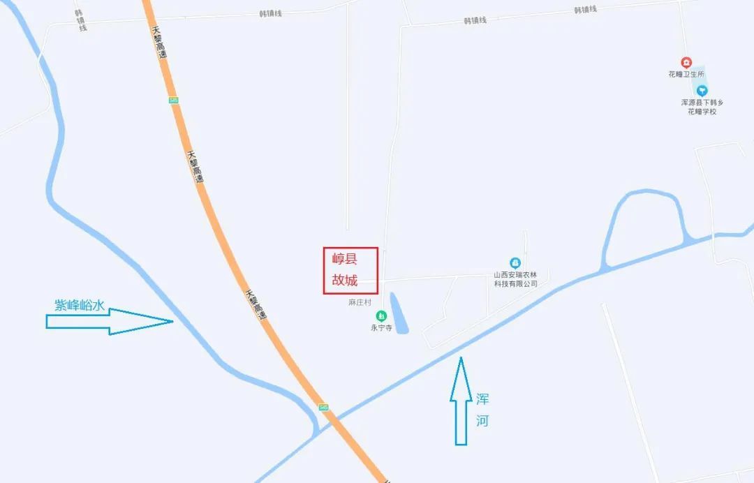
The former city of Hailing County is located north of Mazhuang Village. The earliest record of the geographical location of the former city of Hailing County is in the "Shui Jing Zhu" by Li Daoyuan of the Northern Wei Dynasty. Li Daoyuan lived in Datong and should have been to Hunyuan, so his record is highly credible.
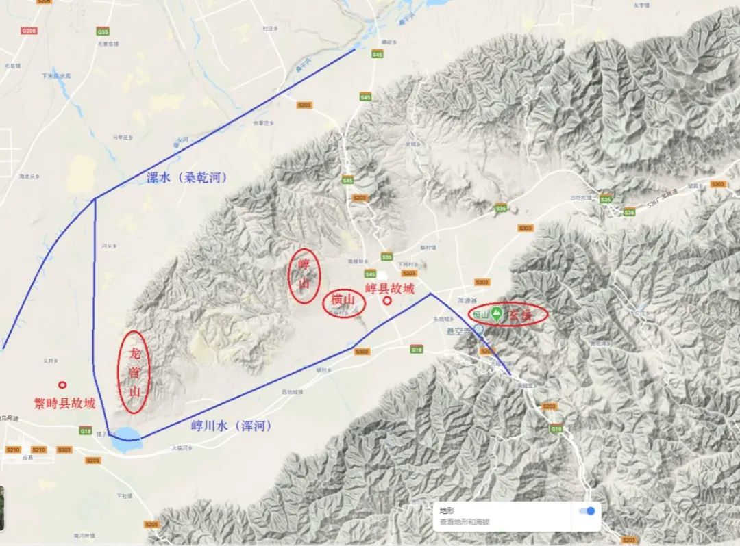
According to Li Daoyuan's records, the former city of Hailing County is south of Hengshan Mountain and to the right of Haishan Mountain. After Tangyu River flows out from the south valley, it turns west, bends north at Zhenziliang Reservoir, passes east of the former city of Fanchi County, and flows into the Sanggan River. [Note: Luoshui (Sanggan River) flows further east for 49 li, passing north of Juwei Pavilion, and further east, where Haichuan Water (present-day Hunhe River) flows into it, and the water (present-day Tangyu River) flows out from the south of the former city of Haixian (present-day Mazhuang Village, Hunyuan County), which is also Zhang of Wang Mang. South of the county is Xuan Yue (present-day Hengshan Mountain), and to the right is Haishan Mountain (present-day Wohu Mountain west of Xiliu Village and west of Quantou Village, Hunyuan County), located between the two mountains, hence the name Haizhang. Its water flows west out of the mountain and is called Haikou, flowing north and passing east of the former city of Fanchi County (present-day Yijing Township, Yingxian County), which was Wang Mang's important strategic location.]
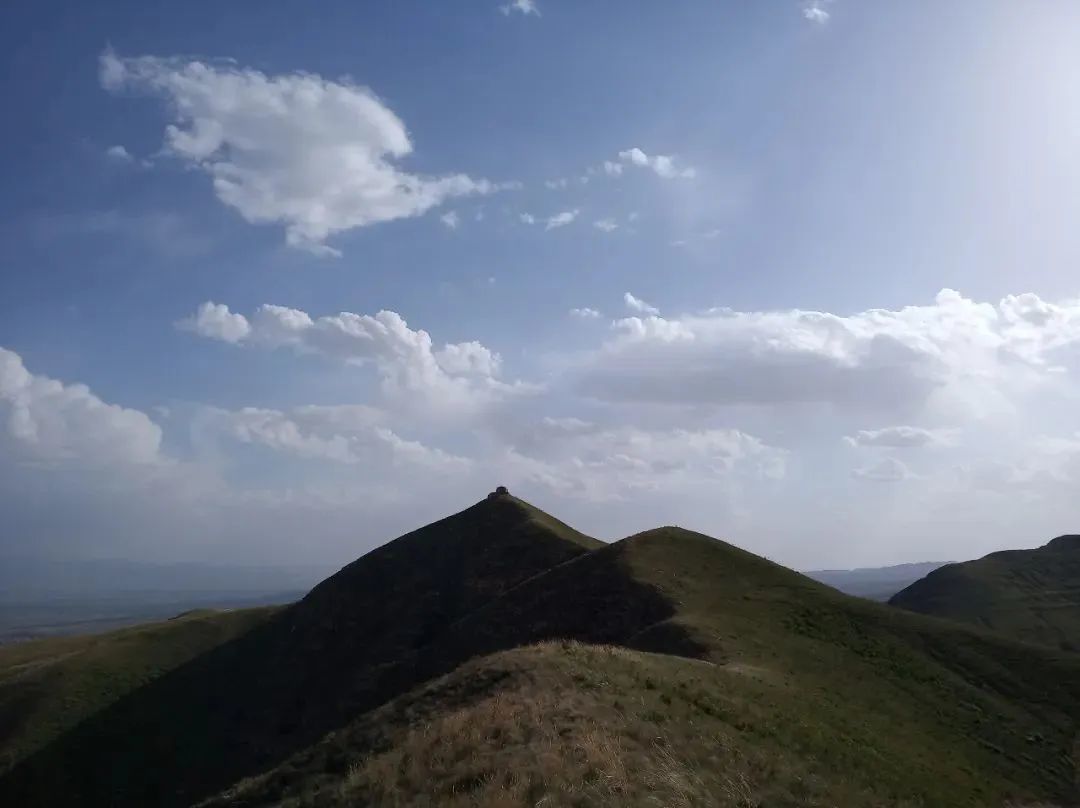
"To the right" refers to the northwest direction. After many on-site surveys, I have confirmed that Haishan Mountain is Wohu Mountain, north of Xiliu Village and east of Quantou Village. The main peak of Wohu Mountain has an altitude of over 1500 meters, with high recognition. People in Bicun call the main peak of Wohu Mountain "Ban Niuer Mountain". Why is it called that? You will know when you look at the map.
The south slope of Wohu Mountain is gentle, and the east slope is steep. Sunjiafen is on the south slope. It is possible that the Sun family asked a feng shui master to choose the location of the tomb. In addition to Sunjiafen, there are two other high-level tombs in Hunyuan: the tomb of Empress Dowager Dou of the Northern Wei Dynasty and the tomb of Taibao Lu Ruyuan. They have not been discovered yet and should be near Sunjiafen.
According to "Weishu", Emperor Wencheng Tuoba Jun hunted on Haishan Mountain. The hunting range should also be on the south side of Wohu Mountain, in the area of Chedaokou, Jiazhuang, Tiancun, and Tuofeng. In the late Tang Dynasty, Li Keyong stationed in Hunhechuan, which should also be in this area. In 2019, I climbed to the top of the main peak of Wohu Mountain several times from the east and south slopes. After reaching the middle of the mountain, one can see the overall pattern of Hunyuan County. According to conventional thinking, there is a trumpet-shaped exit on the west side of Hunyuan, but from the top of Wohu Mountain, Hunyuan is a standard basin. At that moment, I suddenly understood why the Han people called Hunyuan Haixian, because Hunyuan is a natural large city. The "Hai" in Haixian has the same meaning as "Guo" (city walls), and it is specifically used in place names, only Hunyuan and Yuanping have this name, and Yuanping was moved from Hunyuan.
The former city of Hailing County was used from the Han Dynasty to the late Tang Dynasty, lasting more than 1000 years.
From the map, it can be seen that the former city of Hailing County is located between two rivers, with flat terrain, which is conducive to urban planning. The disadvantage is that if there is a heavy rain, the river water will overflow and easily flood the city, so the Later Tang Dynasty moved the old city to the present location of Hunyuan County.
VIII. The Southward Relocation of Hailing County and the Disappearance of its Administrative Division
Hailing County was once moved south of Yanmen Pass in the late Western Jin Dynasty, but it only existed for 7 years.
At the end of the Western Jin Dynasty, the dynasty's power declined under the impact of the War of the Eight Princes. In 310 AD, because the Xianbei Tuoba tribe repeatedly assisted Liu Kun, the governor of Bingzhou, in resisting the Xiongnu. To thank Tuoba Yilu for his help, Liu Kun applied to the central government to enfeoff Tuoba Yilu as the Duke of Dai and promoted him to the position of Grand Chanyu, relocating the residents of the five counties of Mayi, Yinguan, Loufan, Fanchi, and Ao under the jurisdiction of Yanmen County, north of the Hengshan Mountain range, to the south of Yanmen Pass. Afterwards, 100,000 Xianbei households moved into the upper reaches of the Sanggan River, and the north of Yanmen Pass was completely controlled by the Tuoba tribe, with the Hengshan Mountain range becoming the boundary between the Western Jin and Dai states. Since then, Ao County and Hunyuan have had no contact.
The Tuoba Xianbei people's production and lifestyle were mainly nomadic, and their management was relatively lax. The "Book of Wei: Empress's Biography" records that in the early years of the founding of the state (338), Tuoba Shiyijian intended to establish his capital in the Datong Basin, building city walls and palaces. However, he was opposed by his mother, Empress Wang, on the grounds that the Xianbei people were nomadic, and once they settled down, if the enemy attacked, they would probably be helpless. Empress Wang's statement about nomadic lifestyles reflects the characteristics of nomadic peoples. This shows that before the Northern Wei Dynasty established its capital in Pingcheng, the Xianbei people's management of the Datong Basin did not establish counties and register households like the Han people, and the administrative division of Ao County disappeared.
In 398 AD, the Northern Wei Dynasty moved its capital to Pingcheng, establishing the scope of the capital region, extending east to Ulan County, west to Youyu, south to Shuozhou, and north to Yanggao, with Hunyuan becoming an inland area of the capital region. In 494 AD, the Northern Wei Dynasty moved its capital to Luoyang, and the former capital region was changed to Hengzhou.
In 534 AD, the Northern Wei Dynasty perished. The Datong Basin was successively controlled by the Rouran and Turkic people until 556 AD, when Emperor Wenxuan Gao Yang of the Northern Qi Dynasty established Heng'an Town in Datong. The Northern Qi Great Wall at Lingyun Pass was built by the Northern Qi Dynasty to defend against the Turks.
After the Northern Qi Dynasty came the Northern Zhou Dynasty, and after the Sui Dynasty replaced the Northern Zhou Dynasty, it established Mayi County in the Datong Basin. Mayi County was under the jurisdiction of four counties: Shanyang, Yunnei, Shenwu, and Kaiyang. After the Tang Dynasty replaced the Sui Dynasty, it established two prefectures in the Datong Basin: Yunzhou and Shuozhou. Yunzhou had only one county under its jurisdiction, Yunzhong County. Shuozhou had two counties under its jurisdiction: Shanyang County and Mayi County. It was not until 907 AD, after the Tang Dynasty perished, that Shatuo Li Keyong established Yingzhou and Hunyuan County in the Datong Basin. In other words, from the relocation of Ao County south of Yanmen Pass at the end of the Western Jin Dynasty to the demise of the Tang Dynasty, nearly 600 years (310-907), there is no record of the establishment of counties within Hunyuan.
The absence of administrative divisions in Hunyuan does not mean that there was no human activity in Hunyuan. In the 598 years from the Western Jin to the end of the Tang Dynasty, the Datong and Hunyuan areas were successively inhabited by Xianbei, Wuhuan, Rouran, Turkic, Uyghur, Shatuo, and Tuyuhun ethnic minorities. The name Hunyuan County originates from Tuyuhun. Before the Tang Dynasty, the Hun River was originally called Aoquan River. In the middle and late Tang Dynasty, Tuyuhun began to reproduce and multiply in Hunyuan, and it was because of Tuyuhun's production and labor in Hunyuan that Aoquan River was renamed Hun River. The Shend Lake under the L"ul"u Shrine in Shenxi Wetland Park was originally called "Tuyuhun Sea," and it was renamed Shend Lake in the Liao Dynasty. Of course, the local people of Shenxi Village still call Shend Lake Tuyuhun Sea. The Tang River, which originates from Qiangfeng Ridge, was called Pi Shui before the Tang Dynasty, and it was only after the establishment of the Later Tang Dynasty by the Shatuo Li Keyong family that it was called Tang River. Tuyuhun originally lived in Qinghai, and Shatuo originally lived in Xinjiang. They were both ethnic groups skilled in commerce along the Silk Road, and the commercial tradition of Hunyuan people can be traced back to at least the Tang Dynasty.
As for Ao County, which was relocated to the south of Yanmen Pass, seven years later, in 316 AD, Shi Le, the Great General of the Former Zhao Dynasty, launched a military attack on Bingzhou, Liu Kun was defeated, and Bingzhou was completely occupied, and the Ao County immigrants once again embarked on a journey of displacement, wandering and eventually arriving near present-day Yangzhou. In order to settle and manage the displaced people, the Eastern Jin government established Qiaozhi Yanmen County and Ao County on the north bank of the Yangtze River. The southern Qiaozhi Ao County existed for 90 years. In 420 AD, the Southern Qi government reorganized its administrative divisions, and Qiaozhi Yanmen County and Ao County completely disappeared. The Xinding Basin south of Yanmen Pass was successively occupied by the Former Zhao, Later Zhao, Former Yan, Western Yan, and Later Yan during the Sixteen Kingdoms period. It was not until 606 AD, in the second year of Daye in the Sui Dynasty, that Emperor Yang Guang of Sui re-established Ao County south of Yanmen Pass, with its county seat located in present-day Aoyang Town, Yuanping County.
Note: You may be unfamiliar with the Former Zhao, Later Zhao, Former Yan, Western Yan, and Later Yan regimes; they all belong to the Sixteen Kingdoms period. The founding emperor of the Former Zhao, Liu Yuan, was a Xiongnu, and the founding emperor of the Later Zhao, Shi Le, was a Jie. The Former Yan, Western Yan, and Later Yan were also states established by the Xianbei people, and their rulers had the surname Murong, the ancestor of Murong Fu in Jin Yong's novel "The Demi-Gods and Semi-Devils." Murong Fu did exist in history, but his deeds were not as described in the novel. During the Sixteen Kingdoms period, the Former Zhao, Later Zhao, Former Yan, and Later Yan bordered the Dai state along the Hengshan Mountain range. The Dai state was the name of the Northern Wei Dynasty before it moved its capital to Pingcheng. After moving its capital to Pingcheng, it was called Da Wei or Da Dai. The epitaphs of the Northern Wei Dynasty unearthed generally write Da Dai.
Nine. The octagonal city wall and meandering streets of Hunyuan County
Hunyuan County was founded in the Later Tang Dynasty. Because its city walls are octagonal and its streets are winding and tortuous, it is known as "the tortoise city and snake streets." Regarding the origin of Hunyuan County, the Qianlong edition of "Hunyuan Prefecture Records" records: "The old city was located to the west of the city on the left side of Hengshan Mountain, and the city was often flooded, so it was moved to its present location in the Later Tang Dynasty." This means that the old city of Hunyuan was frequently flooded, so it was moved to its current location.
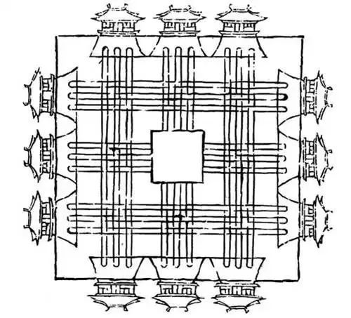
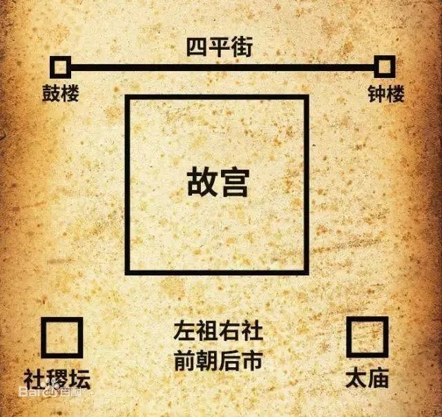
After the relocation, the first thing to do is urban planning. How did the ancients carry out urban construction? The "Zhou Li: Kaogong Ji" provides a standard plan: "Craftsmen build a country, nine li square, with three gates on each side, nine longitudinal and nine latitudinal roads in the country, nine tracks on the longitudinal roads, ancestral temple on the left, and shrine on the right, court in front, and market in the back."
Let me explain this passage to you.
Urban construction should be nine li square, with three gates on each of the four sides, and nine horizontal and nine vertical roads within the city. The royal palace is on the left, and the shrine is on the right. The front is the office area, and the back is the residential area and market. The Forbidden City in Beijing is roughly laid out in this way.
The ideal urban layout is a grid-like city plan, square and orderly. However, in practice, it must be adapted to local conditions. For example, Jiankang, the capital of the Six Dynasties, present-day Nanjing, is bordered by the Yangtze River to the west, Houhu ( Xuanwu Lake) to the north, and Zhongshan Mountain to the east. Buildings could only follow the terrain and waterways, resulting in an irregular layout. "A Record of the World" mentions that Wang Dao, the prime minister of the Eastern Jin Dynasty, when constructing Jiankang, said that because "the Jiangdong region has a narrow terrain, unlike the flat terrain of the Central Plains. If the streets are built straight, they can be seen from end to end. It is better to build them winding and tortuous, making them seem unfathomable." Wang Dao's approach was simply because it was impossible to plan the city in a grid pattern. Hunyuan County is located at the northern foot of Hengshan Mountain, backed by Hengshan Mountain to the south and facing the Hun River to the north. The county gazetteer states: "The earth's veins come from the southeast, forming hills shaped like a turtle, and the city takes after its form, with the battlements winding like a turtle carrying a book." This passage is difficult to understand, but considering the topography and geomorphology, it simply means that Hunyuan County is built along the mountain, and some undulations are necessary to transition to the plains. Hunyuan County is higher in the southeast and lower in the northwest, making it impossible to build straight streets, so the city walls can only follow the terrain, appearing uneven. Compared to Nanjing, Hunyuan County, while also considered a geomantically auspicious location, is smaller in scale. Nanjing is described as "a dragon embracing a tiger", while Hunyuan County is more modestly referred to as a "turtle city with serpentine streets."

The three elements of architecture are practicality, solidity, and aesthetics. The location of Hunyuan County was primarily chosen to avoid water hazards, and the layout of the "turtle city with serpentine streets" was constrained by the terrain. Of course, some local historians believe that it reflects celestial phenomena and that wise rulers should follow them, which is a digression.
During the Later Tang Dynasty, Hunyuan produced a Liu Empress, the only empress in Hunyuan's history. Her husband was Li Congke, the last emperor of the Later Tang Dynasty. When Shi Jingtang allied with the Khitan to conquer Luoyang, the capital of the Later Tang, the Liu Empress and her family burned themselves to death along with the imperial jade seal. After that, the imperial jade seal disappeared without a trace.
Shi Jingtang ceded the Sixteen Prefectures of Yan and Yun to the Khitan to thank them for helping him seize the imperial throne.
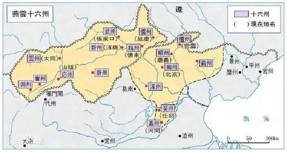
Using the Taihang Mountains as the dividing line, the seven prefectures in Shandong are Youzhou (present-day Beijing), Tanzhou (present-day Miyun District, Beijing), Shunzhou (present-day Shunyi District, Beijing), Jizhou (present-day Jizhou District, Tianjin), Zhuozhou (present-day Zhuozhou City, Hebei), Yingzhou (present-day Hejian City, Hebei), and Mozhou (present-day Renqiu City, Hebei); the nine prefectures in Shanxi are Yunzhou (present-day Datong City, Shanxi), Yingzhou (present-day Ying County, Shuozhou City, Shanxi), Huanzhou (present-day Shanyin County, Shuozhou City, Shanxi), Shuozhou (present-day Shuozhou City, Shanxi), Ruzhou (present-day Yanqing District, Beijing), Guizhou (present-day Huailai County, Zhangjiakou City, Hebei), Wuzhou (present-day Xuanhua District, Zhangjiakou City, Hebei), Xinzhou (present-day Zhuolu County, Zhangjiakou City, Hebei), and Weizhou (present-day Weixian County, Zhangjiakou City, Hebei). The seven prefectures in Shandong were administered with Youzhou (Beijing) as the center, while the nine prefectures in Shanxi were administered with Yunzhou (Datong) as the center.
The Sixteen Prefectures of Yan and Yun have had a profound impact on Chinese history. After the North China Plain lost the protection of the Taihang Mountains, it was constantly threatened by Khitan cavalry. To avoid fighting on two fronts against the Khitan and Xixia, in the first year of the Jingde era of Emperor Zhenzong of Song (1004), a truce was signed with the Liao Dynasty at the city of Chan (present-day Puyang City, Henan), known in history as the "Alliance of Chanyuan," exchanging peace for a hundred years at the cost of an annual tribute of 100,000 taels of silver and 200,000 bolts of silk.
The origin of the name Shanxi Province is also related to the Sixteen Prefectures of Yan and Yun. Before the Yuan Dynasty, Shanxi was called Bingzhou or Hedong Dao/Hedong Lu. Hedong refers to the east of the Yellow River. Following the principle of adapting to natural features, the administrative divisions were established with the Yellow River as a reference. Shanxi, however, was established with the geopolitical struggles during the Five Dynasties and the Liao and Jin Dynasties as the political background and the Taihang Mountains as the reference for the administrative division. After the Yuan Dynasty unified China, it established the Hedong Shanxi Dao Xuanwei Si in Shanxi. During the Yuan Dynasty, the geographical concept of Shanxi gradually replaced the original names such as "Hedong" and "Bingzhou" due to the strengthening of central administrative divisions, thus deriving its current name. In August of the first year of Hongwu (1368), Zhu Yuanzhang, the founding emperor of the Ming Dynasty, sent the generals Xu Da and Chang Yuchun to conquer Dadu (present-day Beijing), ending the Yuan Dynasty and recovering the Sixteen Prefectures of Yan and Yun. In the second year of Hongwu (1369), the Ming Dynasty established the Shanxi Xing Zhongshu Sheng. In the ninth year of Hongwu (1376), it was renamed Shanxi Chengbu Xuanfu Si, and the name Shanxi has been used since then.
Just to clarify, Shanxi Province is west of the Taihang Mountains, hence the name Shanxi. So, is Shandong Province called Shandong because it is east of the Taihang Mountains?
Please refer to the "Diagram of Shandong's Geopolitical Relationships." During the Jin Dynasty, administrative divisions were established using Mount Tai, Mount Lu, Mount Yi, Mount Meng, and Mount Ni as boundaries. East of Mount Tai was Shandong East Road, and west of Mount Tai was Shandong West Road, so the "mountain" in Shandong refers to Mount Tai, not the Taihang Mountains. Of course, as early as the Spring and Autumn Period, Mount Tai was the boundary between the states of Qi and Lu. The division based on Mount Tai still reflects the principle of adapting to natural features.
X. Yang Ye, a brave general of the Northern Song Dynasty, stationed at Hengshan Mountain
There is a village called Luozhiwa in Dongfangcheng Township, Hunyuan County, and a town called Jinshatan Town in Huai'ren City. Legend has it that these were places where the Yang Family Generals and the Khitan fought. Are these legends true? I can tell you that the stories of the Yang Family Generals did indeed take place in Yanbei, and General Yang's army was stationed in the Hengshan Mountain range.
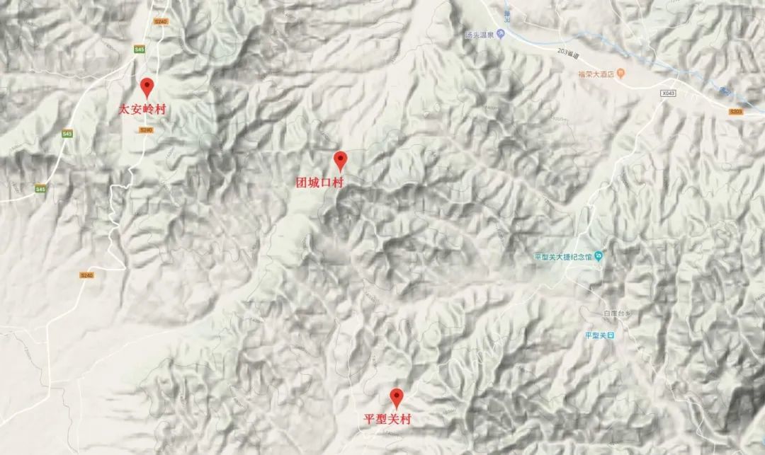
In the early Northern Song Dynasty, to resist the Khitan, Yang Ye built thirteen forts along the Hengshan Mountain range from east to west: Pingxingzhai, Meihui Zhai, Maguzhai, Yixingzhai, Dashinzhai, Ruyuezhai, Huguzhai, Yanmenzhai, Xixingzhai, Tucuizhai, Shixiazhai, Yangwuzhai, and Loubanzhai. The Song military book "Wujing Zongyao" refers to them as the Thirteen Forts along the Border.
After many on-site investigations, I have confirmed that one of the thirteen forts is located in Hunyuan. Can you guess which one it is? Please raise your hand if you know.
The answer is Maguzhai, which is now Ta'anling Village in Wangzhuangbao Town. Ta'anling Village is the boundary between Hunyuan and Fanshi, and it also bears the responsibility of dividing Datong and Xinzhou.
In the first month of the third year of the Yongxi era of the Song Taizong reign (986 AD), the Song army launched a three-pronged northern expedition. The eastern route, led by Cao Bin as the commander-in-chief, commanded the main force of 100,000 troops, departing from Xiongzhou (present-day Xiongxian County, Xiong'an New Area, Hebei Province); the central route, led by Tian Chongjin, departed from Feihux (present-day Laishui County, Hebei Province); and the western route, led by Pan Mei and Yang Ye, departed from Yanguan Pass. The Northern Song Dynasty intended to launch a three-pronged attack, using the eastern route to contain the Liao army's main force, and after the central and western routes seized the nine prefectures of Shanxi, they would turn eastward and encircle Youzhou. However, the eastern route army was the first to be defeated by the Liao army. Subsequently, the central and western route armies were counterattacked by the Liao army, and Yang Ye had to abandon the Datong Basin, which had already been captured, and led more than 100,000 people back. During the retreat, they engaged in a major battle with the Khitan army, suffering a defeat at Chenjiagou, after which Yang Ye died by self-imposed starvation.
Many civilians witnessed Yang Ye's battles with the Khitan, so stories of the Yang family generals were widely circulated and passed down orally in Yanbei. Yang Ye has a biography in the Song History, and he was a famous general of the Northern Song Dynasty, known as "Yang the Invincible." The Song History mentions Yang Ye, always referring to him as a "brave general." However, the demise of such a great general is truly regrettable.
I have a question for everyone: Legend says that Yang Yanzhao guarded three passes. Were these Ningwu Pass, Yanguan Pass, and Pingxing Pass? Those who know, please raise your hand.
According to the Song History, the three passes guarded by Yang Yanzhao were Yijin Pass (in present-day Bazhou City, Hebei Province), Wqiao Pass (in present-day Xiongxian County, Xiong'an New Area, Hebei Province), and Yukou Pass (in present-day Xin'an Town, Bazhou City, Hebei Province). This shows that there are some differences between historical records and fictional accounts.
Many renowned scholars and officials of the Jin and Yuan dynasties came from the north.
During the four dynasties of Jin, Yuan, Ming, and Qing, the administrative divisions of Hunyuan County remained relatively stable. After being upgraded from a county to a prefecture in the second year of Zhenyou in the Jin dynasty, Hunyuan remained Hunyuan Prefecture until the end of the Qing Dynasty.
The methods of selecting officials varied across different dynasties in ancient China. However, whether the population and cultivated land within an official's jurisdiction increased were the two most important criteria for evaluating their performance. Teacher Li has compiled statistics on the household and population of Hunyuan throughout history based on official histories and local gazetteers.
Historical Statistics of Households and Population in Hunyuan
Dynasty |
Statistical Time |
Number of Households |
Population |
Han Dynasty |
Second year of Yuanshi (2 AD) |
Approximately 5000 |
Over 20000 |
Western Jin Dynasty |
1500 |
Over 6000 |
|
Liao Dynasty |
5000 |
Over 20000 |
|
Jin Dynasty |
10000 |
Over 40000 |
|
Ming Dynasty |
Tenth year of Wanli (1582) |
1397 |
12243 |
Qing Dynasty |
Sixteenth year of Shunzhi (1659) |
154 |
3205 |
Sixth year of Guangxu (1919) |
17401 |
140580 |
|
Republic of China |
Eighth year of the Republic of China |
35455 |
182683 |
People's Republic of China |
1949 |
43208 |
173919 |
1995 |
93744 |
330235 |
The table shows that during the Jin Dynasty, Hunyuan Prefecture had over 10,000 households and a population of around 40,000 to 50,000, indicating a prosperous population and a flourishing intellectual atmosphere. During the Jin and Yuan dynasties, many renowned scholars and officials came from the north. At that time, there were four prominent families in Hunyuan: the Liu, Lei, Sun, and Gao families. The Liu and Lei families were known for their literature, while the Sun and Gao families were renowned for their military prowess. After Liu Chi became the first champion of ci and fu poetry in the Jin Dynasty, his sons Liu Ji and Liu Wei; grandsons Liu Kan, Liu Si (granted the title of Jinshi), and Liu Yan; great-grandsons Liu Congyi and Liu Congyu; and great-great-grandson Liu Qi all passed the imperial examinations. Zhao Bingwen, a leading figure in the literary world of the Jin Dynasty, praised the Liu family as a "nest of outstanding talents."
The Liu and Lei families were intermarried. The most famous member of the Lei family was Lei Yuan, a censor, known for his strict law enforcement and fearless impeachment of powerful figures. While combating crime in Caizhou (present-day Runan County, Zhumadian City, Henan Province), he caned 500 people to death, causing a sensation and earning him the nickname "Lei Half-Thousand."
Records of Gao Ding's achievements are scarce. According to the Zhengde edition of the Datong Prefecture Gazetteer, Gao Ding once served as the commander-in-chief of the Yunzhong pacification envoy and the Jiedushi of Yong'an Army. Gao Ding's greatest contribution to Hunyuan was the construction of Yong'an Temple, adding a nationally significant cultural relic protection unit to Hunyuan.
The Sun Wei family was famous for its skill in making armor, earning the admiration of Genghis Khan and Ogedai, who bestowed the name Keye Wulan upon them. The armor made by Sun Wei was called "tendon feather armor." Teacher Li, an enthusiast of ancient weaponry, speculates that the tendon feather armor was likely made using ox tendons as a material. I once consulted a veterinarian friend, who told me that the tendons of a single ox weigh only about two kilograms. In the age of cold weapons, ox tendons were an important material for making bows and crossbows. Therefore, the "tendon feather armor" made by Sun Wei should have been produced in very small quantities and was extremely valuable, often bestowed by the imperial court upon highly meritorious senior generals. Teacher Li, after examining the Yuan History, found that only five people received the feather armor: Zhang Rou, Qie Lie, Mang Wutai, Hong Junqi, and Wan Zhedu.
The Sun family tombs in Xiliu are currently a county-level cultural relic protection unit, and their value is somewhat underestimated. The existing steles in the Sun family tombs have significant literary value, supplementing the deficiencies in the Yuan History. From a literary perspective, the inscriptions were written by first-rate writers such as Wang Yun, Liu Yin, and Yuan Mingshan. From an artifact perspective, the Yuan Dynasty steles are nearly 800 years old, making them extremely precious.
In ancient China, establishing moral character, making literary contributions, and achieving military merit were considered paths to immortality. The people of Hunyuan during the Jin and Yuan dynasties perfectly embodied this traditional concept. At the end of the Yuan Dynasty, when compiling the Jin History, numerous passages from Liu Qi's work, Guiqian Zhi, were cited. Historians often had a habit of adding their own opinions and comments at the end of their writings. For example, in Zuozhuan, we have "the gentleman said," in Shiji, we have "the Grand Historian said," and in Jin History, we often see "Liu Qi of Hunyuan said." Liu Qi's Guiqian Zhi secured his place in history, making him a model scholar of Hunyuan.
XI. The Historical and Cultural Attributes of Hengshan Mountain (Hunyuan)
Teacher Li once conducted a simple statistical analysis. From the establishment of the Qin Dynasty to the fall of the Qing Dynasty, a period of over 2100 years, Hunyuan was ruled by the central dynasties for approximately 1100 years and by various minority ethnic groups such as the Xianbei, Khitan, and Jurchen for about 1000 years. Overall, Hunyuan's culture exhibits a blend of Han and other ethnic influences, demonstrating inclusiveness and diversity. However, as locals of Hunyuan, we tend to overlook the commonplace aspects of our daily lives. Nevertheless, Hunyuan's tangible and intangible cultural heritages possess profound depths waiting to be explored.
A few days ago, I wrote an article titled "The Miraculous Efficacy of Astragalus in Historical Texts." The article mentions that Empress Dowager Liu, mother of Emperor Chen Shubao of the Chen Dynasty, suffered a stroke, resulting in paralysis and inability to speak. Despite seeking medical help from various sources without success, Chen Shubao's brother, Prince Chen Shuqi, recommended the renowned physician Xu Yinzong, who served under him, to his brother. After careful diagnosis, Xu Yinzong prescribed a treatment plan for Empress Dowager Liu: decocting Astragalus and Saposhnikovia root in water, placing the concoction under the bed, and using the steam for fumigation. That night, Empress Dowager Liu was able to speak again, leading to Xu Yinzong's exceptional promotion. For promotional purposes, I personally believe this is a highlight. For instance, the Jin History records that Hengshan Mountain mushrooms were considered tribute items during the Jin Dynasty, and there were thousands of farmers around Hengshan Mountain who harvested mushrooms for the imperial family. This clearly illustrates the popularity of Hengshan Mountain's specialty products 1000 years ago.
Dr. Du Chenghui from Shuozhou, a graduate of the History Department of Minzu University of China, conducted postdoctoral research at the Institute of East Asian Studies, Seoul National University. His doctoral dissertation was titled "A Study of the Liu Family of Hunyuan during the Jin and Yuan Dynasties—Focusing on Liu Qi," demonstrating his profound understanding and lifelong benefit from the historical and cultural value of Hunyuan. Professor Li Runmin from Taiyuan University, a native of Lingqiu County, focuses his research on the Sun Wei family of Hunyuan, publishing numerous papers in academic journals. In 1997, dozens of bronze artifacts from Liyu were included in the Complete Collection of Chinese Bronze Ware published by the Cultural Relics Publishing House. In the works of Professor Li Xueqin, a renowned archaeologist and professor at Tsinghua University, unearthed artifacts from Hunyuan are frequently mentioned. I felt immense pride when I saw the Jin Dynasty Hunyuan kiln porcelain at the Shanxi Museum. Scholars from all over the country have shown immense enthusiasm for Hunyuan, with countless academic papers already published. As people of Hunyuan, we have a duty to promote Hunyuan, integrating culture and tourism to enable tourists to understand and appreciate Hunyuan, thereby propelling the development of Hunyuan's cultural and tourism industry.
Keywords:
Hengshan
Related News
Contact Us
Beiyue Hengshan Scenic Area:
Travel Inquiry:+86-352-8333077
Ticket Inquiry:+86-352-8333031
Travel Complaints:+86-352-8333081
Emergency Rescue:+86-352-8333037
Mount Hengshan Scenic Area Administration Center (Official)
+86-352-8322142
Hanging Temple
+86-352-8327795
Yuemenwan (Hengshan Mountain Gate)
+86-352-8480060 +86-352-8328318 +86-352-8328530
Hengzong
+86-352-8480115
Tianfeng Ridge
+86-352-8480114
Yong'an Temple
+86-352-8322390
Li's Family Cemetery
+86-352-8322381
Hengshan Cableway
+86-352-8322255
Official Media

Tiktok